 |
Click CotswoldWaypoints.pdf for a copy of this report, OR click to read my Cotswold Way report to help plan your own walk and share my walk OR click to view the photo gallery of my walk, OR for my other walks and whatnot click on Wildtramper.com.
Cotswold Way GPS Waypoints
& Take-Along Guide
This report describes a comprehensive set of GPS waypoints and a companion hard copy guide (called the Take-Along Guide) for England's Cotswold Way. The report also lists various how-to information to organized your own Cotswold Way walk. A companion report on the Cotswold Way describes in detail my journey and other how-to information available at www.wildtramper.com.
For long walks, in my opinion, a good quality GPS is extremely important. On my walk I carried a Garmin etrex 30 GPS (superceded from the larger, more comberson Garmin 62S) with downloaded maps. The GPS was always attached to my daypack for easy access and was always turned on. In addition to the GPS, downloaded maps, and sheet maps, I also carried the Take-Along Guide to reference GPS waypoint IDs with directional instructions. The mapset I used was Harvey's National Trail - Cotswold Way which I two-sided, color, photo-copied and then inserted into a waterproof Ortlieb brand (9"x11") map carrier for easy access while on the walk. I found the combination trustworthy, it kept me on track and helped me to quickly return to path when I misstepped.
I can't help but recommend carrying a good quality GPS. A GPS that does not have capacity to hold sufficient waypoints or one with poor satetilite tracking capabilities is probably not up to the job for a serious walk. Nonetheless, these less than ideal GPS units can still be valuable as long as you understand their limitations. One morning while on another long walk I awoke to thick fog that severly hampered visibility especially as I gained elevation. At one point my GPS confirmed I had passed a turnoff into the woods. So I retraced my steps to a point where my GPS indicated the waypost should be, and there the nearly hidden, thick-fog-shrouded waypost guided me to that turn. That following evening I learned at my B&B that a group of walkers lost there way in that day's fog to the extent that they arrived very late into the night to worried B&B hosts. Again, I can't help but recommend carrying a good quality GPS or for that matter any GPS where you can at least spot check your position to a map just in case you misstep, it may save your life.
The waypoints described here identify the main route, numerous alternate paths, and many points of interest. These waypoints were extracted primarily by the routing of Google Maps and verified by my walking the path. These waypoints and the associated Take-Along Guide (a) use independent waypoint ID prefixes to identify the main route (Cnnn) from common alternate paths (Annn or Bnnn) and adds numerous points of interest (Pnnn), hotels/lodging (Hnnn), food/pubs (Fnnn), and railroad crossings (Xnnn), (b) uses unique GPS display icons to more easily demark alternate paths and points of interest from the main path, (c) includes descriptions with heading directions such as N (north), S, E, W, (d) includes elevations, and (e) provides a hard copy of pertinent waypoint data that is expected to be used as a Take-Along Guide with your GPS.
About the Files:
File |
Description |
How & where to get |
It is recommended that these files be downloaded using your browser's save link as option rather than just clicking on the link. The files are available from the website of www.wildtramper.com. |
All of the following files packaged into a single *.zip file. |
|
This file. |
|
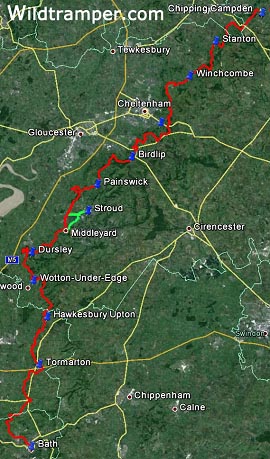
GPS waypoint files for the Cotswold Way starting from Chipping Campden walking southward through towns Stanton, Winchcombe, Cheltenham, Birdlip, Painswick, Stroud, Middleyard, Wotton-Under-Edge, Hawkesbury Upton, Tormarton to Bath. This set includes waypoints of the main path, several alternate paths, and numerous points of interest. |
|
CotswoldWaypointsGuide.pdf
|
Consolidated waypoint list which is intended to be printed double-sided, then clear-plastic laminated, and then sliced into 2 inch wide columns to be used as a Take-Along Guide for use with your GPS. |
A readable text file of waypoints and miscellaneous information. It is a spreadsheet which can be imported into MS Excel. The tab-delimited report has column heading: # (reference number), WP (waypoint ID), WGS-Lat (WGS-84 latitude), WGS-Lon (WGS-84 longitude), Elev (elevation), OSGB-Grid, Miles (accumulated miles), Grade (approximate % grade), and Description. |
|
The primary waypoint input data which is used by software utility makegpx.exe to create: (1) GPS waypoint *.gpx file, (2) Waypoint report (text) file, and (3) Waypoint PDF Take-Along Guide. |
Details:
WP |
OSGB |
Elev |
Cotswold Way
|
Take-Along Waypoint Guide |
C001 |
SP1507 |
144 |
Begin, Market Hall, W on High St |
|
H001 |
SP1504 |
144 |
The Kings Hotel |
|
C002 |
SP1485 |
145 |
R, head NW on Hoo Ln by Volunteer Inn |
|
C003 |
SP1428 |
213 |
L, head NW on Kingcomb Ln |
|
C004 |
SP1421 |
215 |
Turn R on cartpath |
|
C005 |
SP1407 |
222 |
Dovers Hill, turn L, head W |

All total, this waylist version for the Cotswold Way includes more than 400 waypoints: 292 along the main route, 14 alternate paths comprising 72 waypoints, and 55 waypoints demarking various points-of-interest. In addition to the GPS *.gpx waypoint file, a PDF file of handy waypoint information makes a useful Take-Along Guide to supplement the GPS while walking. It is intended to be printed double-sided, then clear-plastic laminated, and then sliced into 2 inch wide columns to be carried as a quick reference with your GPS.
The GPS waypoint file is called CotswoldWaypoints.gpx. It uses multiple categories of IDs represented by unique GPS icon display symbols: Main Cotswold Way waypoints (Cnnn) are identified with a green flag, alternate (Annn) path waypoints with a red flag, alternate (Bnnn) path waypoints with a blue flag, points-of-interest (Pnnn) waypoints with a blue pin, pub/food (Fnnn) with the bar-icon, lodging (Hnnn) with the lodging-icon, and railroad stations (Xnnn) with the crossing-icon.
Although GPS *.gpx files are always specified with the WGS-84 (World Geodetic Standard, 1984) datum in decimal-degree longitude-latitude, the table of the Take-Along Guide uses the OSGB grid system to coordinate with hard copy maps of the Cotswold Way. Therefore, you should configure your GPS to the OSGB grid system. Additionally, I suggest when you arrive at the start of the Cotswold Way, you should instruct your GPS that this is a new location so that it will more quickly synchronize with satellites. This also might be an excellent time to synchronize your camera clock with GPS time.
The table for the Take-Along Guide identifies the waypoint path in four column slices. The first column identifies the waypoint ID (WP) followed by the accumulated distance in miles (Miles). The second column identifies the OSGB grid to a resolution of 10x10 meters. The third column identifies the Elevation in meters as extracted from Google Earth followed by a very approximate +/- % incline, so an incline of say 2% relates to a gentle rise in elevation, while an incline of say -30% implies a very steep loss in elevation likely with zigzags along the path. The forth column is a Description.
The description field is generally concise. Heading directions are abbreviated as single letters of N, S, E, W or compound directions such as ESE. Turning right or left use letters R and L. While w/ means with, e.g. Bear R, head NE w/wall on right interprets as Bear right, head northeast with wall on right.
Alternate Paths:
When I walked the Cotswold Way I often chose alternate paths, and the waypoint file contains many such alternatives. On several days I played tourist by taking local transportation to nearby highlights (listed in a subsequent table). The alternate paths I walked are identified with an asterisk * in the Set column of the table below. It is worthwhile to note that for the paths I did not walk those waypoints I could not later confirm with my GPS tracks, rather they have been confirmed as much as possible with Google Earth. If you find any significant discrepancies, please contact me (preferably supported with a GPS track list) at info@wildtramper.com so the waypoints can be corrected.
Set |
Waypoint IDs |
Description |
1 |
A024-A028 |
Shorter route by 0.5 mile to Stanton |
*2* |
A033-A037 |
Shorter route by 1.1 mile thru Hailes Wood rather than thru Stumps Cross |
*3* |
A048-A055 |
Shorter route by 3.0 mile |
4 |
B056-B062 |
Alternate shorter route to A048-A055 by 3.1 mile |
*5* |
A075-A076 |
Off-track to Charlton Kings Hotel at outskirts of Cheltenham, 0.8 mile |
6 |
A078-A084 |
A longer route by 1.5 mile along Chatcombe Wood |
*7* |
A096-A097 |
Off-track to Birdlip, 0.1 mile |
8 |
A126-A132 |
Shorter route by 2.4 mile to skip Maitlands Wood |
9 |
A144-A153 |
Alternate route along Stroud Waterway and Selsley Common to rejoin at Middleyard |
*10* |
A144-A145 |
Alternate routes along Stroud Waterway to Stroud and nearby train station (which I used to explore Gloucester on my layover day) |
*11* |
B151-B155 |
Return route from Stroud, then onto Selsley Common to rejoin at Middleyard |
12 |
A162-A165 |
Alternate route to Cam Peak and then onto Dursley |
13 |
B170-B171 |
Shorter route by 2.7 mile to skip Stinchcombe Hill golf course |
*14* |
A213-A214 |
Off-track to Hawksbury Upton and Fox Inn, 0.4 mile |
Maps and Reference Guides:
1) Harvey's "National Trail - Cotswold Way" polyethylene map is continuous strip maps to 1:40000 scale. These maps identify mostly the main route and some nearby off-route locations. I double-sided, color, photo-copied 8-1/2"x11" map sections to carry as a reference on my walk which I placed in a waterproof Ortlieb brand (9"x11") map carrier for easy access.
2) "The Cotswold Way" guidebook by Kev Reynolds, published by Cicerone. The book contains both map and guide, however the maps are generally small and fragmented, and thus I found them awkward to use.
3) My GPS was downloaded with Great Britian contour maps. Although these maps should be available through your GPS manufacturer, I chose to use free open source maps (from talkytoaster.co.uk/ukmaps.htm OR from www.velomap.org) and I found these maps were both detailed and reliable.
Lodging and Gear Transfer:
I used Sherpa Van (www.sherpavan.com) for gear transfer, and found their service very reliable. Besides gear transfer, their website lists extensive places to stay along the track. You can arrange your own accommodations (as I did) or they can do that for you. Refer to my trip report for a list of the places I stayed along with a few comments.
Google Earth:
When planning your trip, you may find it useful to view the path via Google Earth (a free software download). With Google Earth, you can upload the *.gpx waypoint file to view the terrain. If you plan to customize the waypoint list, Google Earth is a valuable tool.
Customized *.gpx Files:
For the adventurous you can modify the waypoint list to create your own *.gpx GPS waypoint file or a new *.pdf guide file or a new *.txt report file. The author created a Windows command line utility called makegpx.exe. It converts a text file with lines of space/tab delimited {WaypointID Longitude Latitude [OptionalElevation] Description} into a *.gpx file and/or *Guide.pdf file and/or *Report.txt file. Get this tool from www.wildtramper.com.
Notes and References:
The Wildtramper would like to thank those who preceded him to help generate this waypoint file. Hopefully this version will find wide acceptance and some future trampers will improve upon this work.
1) A description of British Grid can be found from England's Ordnance Survey.
2) Elevations were extracted from Google Earth.
3) The accumulated distance values in the table was obtained by first using the British grid northing and easting values along with the Google Earth's elevation to generate (x,y,z) coordinates. The distance between these coordinates were then calculated and accumulated. The result yielded a total distance of about 9% less than the expected. Hence, the values in the table were then tweaked higher.
4) The % incline values in the table was calculated as the straight line slope between adjacent waypoints. Because the waypoints are often distant from each other, the incline values are at best approximate. Large incline values, certainly those greater than 15%, generally mean steep slopes and maybe a path between the waypoints with zigzags or switchbacks to make the elevation gain or loss more tolerant.