
Click WicklowWaypoints.pdf for a copy of this report, OR click to read my other Irish walking adventures along the Dingle Way OR on the Aran Island of Inis Mór OR view my photo gallery.
Wicklow Way GPS Waypoints & Take-Along Guide
|
This report primarily describes a comprehensive set of GPS waypoints and a companion hard copy guide (called the Take-Along Guide) for Ireland's Wicklow Way. The report also lists various how-to information to organized a Wicklow Way walk, and it presents highlights from my May 2011 walk.
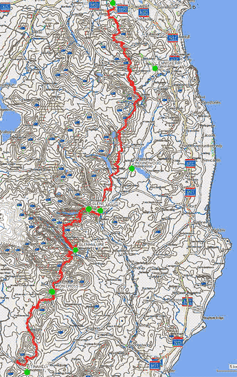
The waypoints cover most of the path, from the trailhead in the north at Marlay Park to Tinahely in the south. Although the path is most commonly walked from north to south, I walked it from south to north. In this direction the weather, wind and rain, was at my back, while the most scenic sections I enjoyed during my final days in the north. If you plan to walk the entire route, then south to north may be your best choice, however if you plan to walk only the most scenic sections, those north of Glenmalure, then I suggest walking from north to south so as to enjoy the hospitality of the Glenmalure Lodge at the end. I recommend using these GPS waypoints and the Take-Along Guide (described herein) in conjunction with a proper set of maps of the path, one that uses the Irish grid and coordinate system.
Of course a good quality GPS is important. On my walk I carried a Garmin 60C GPS with downloaded maps. The GPS was always attached to my daypack strap for easy access and was always turned on. In addition to the GPS, downloaded maps, and sheet maps, I also carried the Take-Along Guide to reference GPS waypoint IDs with directional instructions, and the mapset I preferred was The Wicklow Way Map Guide (1:50,000 scale) from EastWest Mapping which I two-sided, color, photo-copied and then inserted into a waterproof Ortlieb brand (9"x11") map carrier for easy access. I found the combination trustworthy, it kept me on track and helped me to quickly return to path when I misstepped.
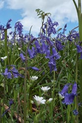
Bluebells |
I can't help but recommend carrying a good quality GPS. A GPS that does not have capacity to hold sufficient waypoints or one that has poor satetilite tracking capabilities is probably not up the job for a serious walk. Nonetheless, these less than ideal GPS units can still be valuable as long as you understand their limitations. One morning of my Wicklow Way walk I awoke to thick fog that severly hampered visibility especially as I gained elevation. At one point my GPS confirmed I had passed a turnoff into the woods. So I retraced my steps to a point where my GPS indicated the waypost should be, and there the nearly hidden, thick-fog shrouded waypost guided me to that turn. That following evening I learned at my B&B that a group of walkers lost there way in that day's fog to the extent that they arrived very late into the night to worried B&B hosts. Again, I can't help but recommend carrying a good quality GPS or for that matter any GPS where you can at least spot check your position to a map just in case you misstep, it may save your life.
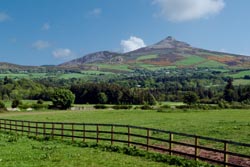
Pastorial |
The waypoints described here identify the main route, numerous alternate paths, and many points of interest. These waypoints were adapted from track-logs by others [see reference list below] and verified by my walking the path. These waypoints and the associated Take-Along Guide (a) use independent waypoint ID prefixes to identify the main route (Wnnn) from common alternate paths (Xnnn or Ynnn) and adds numerous points of interest (Znnn), (b) uses unique GPS display icons to more easily demark alternate paths and points of interest from the main path, (c) includes descriptions with heading directions such as N (north), S, E, W, (d) includes elevations, and (e) provides a hard copy of pertinent waypoint data that is expected to be used as a Take-Along Guide with your GPS.
About the Files:
File |
Description |
How & where to get |
It is recommended that these files be downloaded using your browser's save link as option rather than just clicking on the link. The files are available from the website of www.wildtramper.com. |
All of the following files packaged into a single *.zip file. |
|
This file. |
|
GPS waypoint files for the Wicklow Way walking from the trailhead in the north at Marlay Park to the south at Tinahely or visa-versa. This set includes waypoints of the main path, several alternate paths, and numerous points of interest. |
|
WicklowWaypointsNSGuide.pdf |
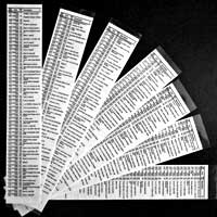
Consolidated waypoint lists (north to south OR south to north) which is intended to be printed double-sided, then clear-plastic laminated, and then sliced into 2 inch wide columns to be used as a Take-Along Guide for use with your GPS. |
A readable text file of waypoints and miscellaneous information. It is a spreadsheet which can be imported into MS Excel. The tab-delimited report has column heading: # (reference number), WP (waypoint ID), WGS-Lat (WGS-84 latitude), WGS-Lon (WGS-84 longitude), Elev (elevation), IRISH-Grid, KM (accumulated kilometers), Grade (approximate % grade), and Description. |
|
The primary waypoint input data which is used by software utility makegpx.exe to create: (1) GPS waypoint *.gpx file, (2) Waypoint report (text) file, and (3) Waypoint PDF Take-Along Guide. |
Details:
All total, this waylist version for the Wicklow Way includes more than 260 waypoints: 193 along the main route, about 8 alternate paths comprising 54 waypoints, and 18 waypoints demarking points-of-interest. In addition to the GPS *.gpx waypoint file, a PDF file of handy waypoint information makes a useful Take-Along Guide to supplement the GPS. It is intended to be printed double-sided, then clear-plastic laminated, and then sliced into 2 inch wide columns to be carried as a quick reference with your GPS.
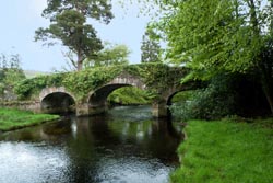
Derrybawn Bridge, circe 1700 |
The GPS waypoint files are called WicklowWaypointsN2S.gpx or WicklowWaypointsS2N.gpx for walking north to south or visa-versa. Both sets use identical waypoint IDs, however the waypoint descriptions describe appropriate N2S or S2N turning instructions. It uses four categories of IDs represented by four GPS icon display symbols: Main Wicklow Way waypoints (Wnnn) are identified with a red flag, alternate (Xnnn) path waypoints with a blue flag, alternate (Ynnn) path waypoints with a green flag, and points-of-interest (Znnn) waypoints with a blue pin. Points-of-interest may be historic, or certain on-route pubs/dining, or lodging.
Although GPS *.gpx files are always specified with the WGS-84 (World Geodetic Standard, 1984) datum in decimal-degree longitude-latitude, the table of the Take-Along Guide uses the Irish grid system to coordinate with hard copy maps of the Wicklow Way. Therefore, you should configure your GPS to the Irish grid system. Additionally, when you arrive at the start of the Wicklow Way, you should instruct your GPS that this is a new location so that it will more quickly synchronize with satellites.
WP |
IRISH |
Elev |
Marlay-Tinahely |
Take-Along Waypoint Guide |
W001 |
E3:1554 |
86 |
START - Marlay Park carpark |
|
W002 |
E3:1559 |
97 |
Cross Little Dargle River |
|
W003 |
E3:1577 |
100 |
Turn R, head W along College Rd |
|
W004 |
E3:1482 |
123 |
Turn L, S, under M50 |
|
W005 |
E3:1481 |
121 |
Ahead, S |
|
W006 |
E3:1507 |
207 |
Turn L, head E |
The table for the Take-Along Guide identifies the waypoint path in four column slices. The first column identifies the waypoint ID (WP) followed by the accumulated distance in kilometers (KM). The second column identifies the IRISH grid to a resolution of 10x10 meters. The third column identifies the Elevation in meters as extracted from Google Earth followed by an approximate +/- % incline, so an incline of say 2% relates to a gentle rise in elevation, while an incline of say -30% implies a very steep loss in elevation probably with zigzags along the path. The forth column is a Description.
The description field is generally concise. Heading directions are abbreviated as single letters of N, S, E, W or compound directions such as ESE. Turning right or left use letters R and L. While w/ means with, e.g. Bear R, head NE w/wall on right interprets as Bear right, head northeast with wall on right.
Alternate Paths:
When I walked the Wicklow Way I sometimes chose alternate paths, and the waypoint file contains many such alternatives. The alternate paths I walked are identified with an asterisk * in the Set number column of the table below. It is worthwhile to note that for the paths I did not walk those waypoints I could not later confirm with my GPS tracks, rather they have been confirmed as much as possible with Google Earth. If you find any significant discrepancies, please contact me (preferably supported with a GPS track list) at info@wildtramper.com so the waypoints can be corrected.
Set |
Waypoint IDs |
Description |
1 |
X054-X057 |
Djouce Mountain |
*2* |
X074-X077 |
Village of Roundwood |
3 |
Y075-Y085 |
Scarr Mountain |
*4a* |
X092-X097 |
Shortcut to/from Laragh from/to track to north |
5 |
X110-X119 |
The Spinc |
6 |
X142-X153 |
Croaghanmoira Mountain |
*7* |
X174 |
Moyne Church |
Maps and Reference Guides:
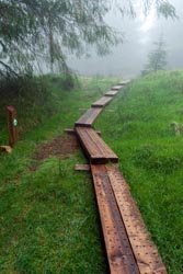
Boardwalk |
1) My primary reference for sheet maps of the Wicklow Way was "The Wicklow Way Map Guide" published by EastWest Mapping. It is both a 1:50,000 scale map set and a concise reference guide. Although the maps are Irish grid, they lack numerical indexing along the border, however a permanent marking pen can easily resolve this shortcoming. With indexes penned in, I double-sided, color, photo-copied the maps to carry as a reference on my walk which I placed in a waterproof Ortlieb brand (9"x11") map carrier for easy access.
2) My GPS was downloaded with Irish contour maps. Although these maps should be available through your GPS manufacturer, I chose to use free open source maps from Talky Toaster, and I found these maps were both detailed and reliable.
3) EastWest Mapping has 1:30,000 scale sheet maps with the Wicklow Way highlighted.
4) Ireland's Ordnance Survey provides numerous 1:50,000 scale sheet maps from their Discovery series.
5) Rucksack Readers publishes "The Wicklow Way," available from EastWest Mapping. This is both map and guide, however the maps sadly have no grid reference.
Noteworthy:
| |
|
For the most part I followed the official Wicklow Way route. However, there were several alternate paths I chose to walk. The following is my noteworthy list of track sections I enjoyed, and these sections are identified by waypoint ID, e.g. (Z100) Saint Saviour's Church.
1) My favorite section of track was along the peaceful, rambling, Glencree River (W039-W041) where an impressive display of bluebell wildflowers were in glorious bloom in early May.
2) My favorite walking day was the track between Enniskerry and Roundwood, (W031-W071).
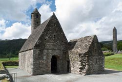
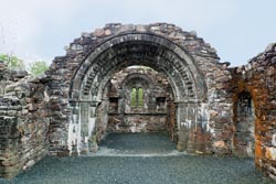
3) Although I had an extra day to explore the antiquities at Glendalough, the afternoon of my arrival provided me with sufficient time to view its very best. Generally the walking time to Glendalough from the previous day's lodging (from either the north or south) should give you a full afternoon to explore. On this afternoon I explored the extensive antiquities of Glendalough (Z101), walked the Green Road towards Laragh and along the way visited the antiquities of Saint Saviour's Church, (circa 12th century at Z100), then continued on to cross the wonderful Derrybawn Bridge, (circa 1700, at X100), and finally arrived at my B&B in Laragh. That evening I had an stupendous dinner at the Wicklow Heather (Z098), eating in their Writer's Room where signed first editions of numerous early 20th century Irish writers grace the walls. On my extra day I walked to the mine ruins, but I found those antiquities and that walk less impressive.
4) The best of the Wicklow Way was the track between Enniskerry in the north to Glenmalure Lodge in the south. This section can easily be walked in three days: (Day 1) Enniskerry walking south to Roundwood, (Day 2) Roundwood to Glendalough/Laragh, and (Day 3) Laragh to Glenmalure. If you can arrange a walk in May, the wildflowers along the Glencree River are most impressive.
Lodging and Gear Transfer:
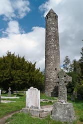
Glendalough Round |
The best source for lodging and gear transfer along the Wicklow Way is WicklowWay.com. Rather, on my walk I used a service to organize my lodging and gear transfer, but I thought many of their choices deficient especially when needless walks were required to village centers (sometimes in foul weather) for dining. I therefore cannot recommend that service, Footfalls Walking Holidays. There are, of course, many other services which can arrange Irish walks, and if you choose to use one of these I suggest that you confirm that the lodging they select for you is near village centers where an assortment of pubs and restaurants might be and that the lodging is also as nearby the walking track as possible.
From my walk I can recommend two lodgings:
• Glenmalure Lodge, located on the track in Glenmalure.
• Woodbrook B&B, 353-404-45699, located off the track in Laragh. Nearby in Laragh is the Wicklow Heather, a wonderful place for dining, and if you eat there ask to be seated in their writer's room where numerous first edition books of 20th century Irish authors grace the walls.
Google Earth:
When planning your trip, you may find it useful to view the path via Google Earth (a free software download). With Google Earth, you can upload the *.gpx waypoint file to view the terrain. If you plan to customize the waypoint list, Google Earth is a valuable tool.
| |
|
Customized *.gpx Files:
For the adventurous you can modify the waypoint list to create your own *.gpx GPS waypoint file or a new *.pdf guide file or a new *.txt report file. The author created a Windows command line utility called makegpx.exe. It converts a text file with lines of space/tab delimited {WaypointID Longitude Latitude [OptionalElevation] Description} into a *.gpx file and/or *Guide.pdf file and/or *Report.txt file. Click here to get this tool.
Notes and References:
The Wildtramper would like to thank those who preceded him to help generate this waypoint file. Hopefully this version will find wide acceptance and some future trampers will improve upon this work.
1) Much of the primary reference for waypoints were track files obtained from WikiLoc.
2) A description of Irish Grid can be found from Ireland's Ordnance Survey.
3) Elevations were extracted from Google Earth.
4) The accumulated distance values in the table was obtained by first using the Irish grid northing and easting values along with the Google Earth's elevation to generate (x,y,z) coordinates. The distance between these coordinates were then calculated and accumulated. The result yielded a total distance of about 9% less than the expected. Hence, the values in the table were then tweaked higher.
5) The % incline values in the table was calculated as the straight line slope between adjacent waypoints. Because the waypoints are often distant from each other, the incline values are at best approximate. Large incline values, certainly those greater than 15%, generally mean steep slopes and maybe a path between the waypoints with zigzags or switchbacks to make the elevation gain or loss more tolerant.