
Click DingleWaypoints.pdf for a copy of this report, OR click to read my other Irish walking adventures along the Wicklow Way OR on the Aran Island of Inis Mór OR view my photo gallery.
Dingle Way GPS Waypoints & Take-Along Guide
|
This report primarily describes a comprehensive set of GPS waypoints and a companion hard copy guide (called the Take-Along Guide) for Ireland's Dingle Way. The report also lists various how-to information to organized a Dingle Way walk, and it presents highlights from my May 2011 walk.
The waypoints encompass a five day walk for most of the Dingle Way traveling in a clockwise manner, a walk which chiefly skirts the Dingle Peninsula coastline. The walk starts from the village of Camp in the northeast with overnights in Anascaul and Dingle along the south, Dunquin along the west, and Ballydavid and Cloghane along the north. I recommend using these GPS waypoints and the Take-Along Guide (described herein) in conjunction with a proper set of maps of the path, one that uses the Irish grid and coordinate system.
| |
|
Of course a good quality GPS is important. On my walk I carried a Garmin 60C GPS with downloaded maps. The GPS was always attached to my daypack strap for easy access and was always turned on. In addition to the GPS, downloaded maps, and sheet maps, I also carried the Take-Along Guide to reference GPS waypoint IDs with directional instructions, and the mapset I used was The Discovery Series (1:50,000 scale) from Ireland's Ordnance Survey (maps 70 and 71) which I two-sided, color, photo-copied and then inserted into a waterproof Ortlieb brand (9"x11") map carrier for easy access. I found the combination trustworthy, it kept me on track and helped me to quickly return to path when I misstepped.
I can't help but recommend carrying a good quality GPS. A GPS that does not have capacity to hold sufficient waypoints or one with poor satetilite tracking capabilities is probably not up the job for a serious walk. Nonetheless, these less than ideal GPS units can still be valuable as long as you understand their limitations. One morning while on another long walk I awoke to thick fog that severly hampered visibility especially as I gained elevation. At one point my GPS confirmed I had passed a turnoff into the woods. So I retraced my steps to a point where my GPS indicated the waypost should be, and there the nearly hidden, thick-fog-shrouded waypost guided me to that turn. That following evening I learned at my B&B that a group of walkers lost there way in that day's fog to the extent that they arrived very late into the night to worried B&B hosts. Again, I can't help but recommend carrying a good quality GPS or for that matter any GPS where you can at least spot check your position to a map just in case you misstep, it may save your life.
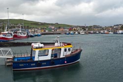
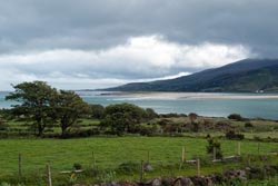
Dingle Harbour |
The waypoints described here identify the main route, numerous alternate paths, and many points of interest. These waypoints were adapted from track-logs by others [see reference list below] and verified by my walking the path. These waypoints and the associated Take-Along Guide (a) use independent waypoint ID prefixes to identify the main route (Dnnn) from common alternate paths (Annn or Bnnn) and adds numerous points of interest (Cnnn), (b) uses unique GPS display icons to more easily demark alternate paths and points of interest from the main path, (c) includes descriptions with heading directions such as N (north), S, E, W, (d) includes elevations, and (e) provides a hard copy of pertinent waypoint data that is expected to be used as a Take-Along Guide with your GPS.
About the Files:
File |
Description |
How & where to get |
It is recommended that these files be downloaded using your browser's save link as option rather than just clicking on the link. The files are available from the website of www.wildtramper.com. |
All of the following files packaged into a single *.zip file. |
|
This file. |
|
GPS waypoint files for the Dingle Way starting from the village of Camp walking clockwise through villages Anascaul, Dingle, Dunquin, Ballydavid, and then over Mount Brandon to the village of Cloghane. This set includes waypoints of the main path, several alternate paths, and numerous points of interest. |
|
DingleWaypointsGuide.pdf
|
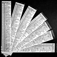
Consolidated waypoint list which is intended to be printed double-sided, then clear-plastic laminated, and then sliced into 2 inch wide columns to be used as a Take-Along Guide for use with your GPS. |
A readable text file of waypoints and miscellaneous information. It is a spreadsheet which can be imported into MS Excel. The tab-delimited report has column heading: # (reference number), WP (waypoint ID), WGS-Lat (WGS-84 latitude), WGS-Lon (WGS-84 longitude), Elev (elevation), IRISH-Grid, KM (accumulated kilometers), Grade (approximate % grade), and Description. |
|
The primary waypoint input data which is used by software utility makegpx.exe to create: (1) GPS waypoint *.gpx file, (2) Waypoint report (text) file, and (3) Waypoint PDF Take-Along Guide. |
Details:
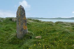
Ballinrannig Standing Stone |
All total, this waylist version for the Dingle Way includes more than 250 waypoints: 152 along the main route, 13 alternate paths comprising 63 waypoints, and 21 waypoints demarking points-of-interest. In addition to the GPS *.gpx waypoint file, a PDF file of handy waypoint information makes a useful Take-Along Guide to supplement the GPS. It is intended to be printed double-sided, then clear-plastic laminated, and then sliced into 2 inch wide columns to be carried as a quick reference with your GPS.
The GPS waypoint file is called DingleWaypoints.gpx. It uses four categories of IDs represented by four GPS icon display symbols: Main Dingle Way waypoints (Dnnn) are identified with a red flag, alternate (Annn) path waypoints with a blue flag, alternate (Bnnn) path waypoints with a green flag, and points-of-interest (Cnnn) waypoints with a blue pin. Points-of-interest may be historic, or certain on-route pubs/dining, or lodging.
WP |
IRISH |
Elev |
Camp-Cloghane |
Take-Along Waypoint Guide |
D001 |
E0:6961 |
66 |
Camp Cross, S @ St Mary's Church / N86 |
|
C001 |
E0:6959 |
66 |
James Ashe Bar |
|
D002 |
E0:6982 |
92 |
Bear R, head SW |
|
D003 |
E0:6865 |
231 |
Turn L, head SE (Maumnahaltora) |
|
D004 |
E0:6866 |
220 |
Curve R to W |
|
D005 |
E0:6777 |
186 |
Slight curve L to SW |
Although GPS *.gpx files are always specified with the WGS-84 (World Geodetic Standard, 1984) datum in decimal-degree longitude-latitude, the table of the Take-Along Guide uses the Irish grid system to coordinate with hard copy maps of the Dingle Way. Therefore, you should configure your GPS to the Irish grid system. Additionally, when you arrive at the start of the Dingle Way, you should instruct your GPS that this is a new location so that it will more quickly synchronize with satellites.
The table for the Take-Along Guide identifies the waypoint path in four column slices. The first column identifies the waypoint ID (WP) followed by the accumulated distance in kilometers (KM). The second column identifies the IRISH grid to a resolution of 10x10 meters. The third column identifies the Elevation in meters as extracted from Google Earth followed by a very approximate +/- % incline, so an incline of say 2% relates to a gentle rise in elevation, while an incline of say -30% implies a very steep loss in elevation probably with zigzags along the path. The forth column is a Description.
The description field is generally concise. Heading directions are abbreviated as single letters of N, S, E, W or compound directions such as ESE. Turning right or left use letters R and L. While w/ means with, e.g. Bear R, head NE w/wall on right interprets as Bear right, head northeast with wall on right.
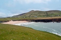
Clogher Beach & Bay |
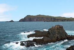
Cliff Walk near Clogher Bay |
Alternate Paths:
When I walked the Dingle Way I often chose alternate paths, and the waypoint file contains many such alternatives. The alternate paths I walked are identified with an asterisk * in the Set number column of the table below. It is worthwhile to note that for the paths I did not walk those waypoints I could not later confirm with my GPS tracks, rather they have been confirmed as much as possible with Google Earth. If you find any significant discrepancies, please contact me (preferably supported with a GPS track list) at info@wildtramper.com so the waypoints can be corrected.
Set |
Waypoint IDs |
Description |
*1* |
A009-A015 |
Sammy's Cafe on Inch Beach |
*2* |
A028-A029 |
Lugnapappul, 3 standing stones |
3 |
A070-A074 |
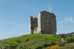
Rahinnane Castle |
*4* |
A082-A090 |
Fort Dunbeg and Beehive Huts antiquities (and The Stonehouse Cafe) |
5 |
B085-B087 |
Optional high path return for Fort Dunbeg and Beehive Hut antiquities |
*6* |
A095-A097 |
Coumeenole Beach near Slea Head |
*7* |
A100 |
Village of Dunquin |
*8* |
A108-A118 |
Stupendous Cliff Walk, a must visit |
*9* |
A121 |
Ballinranning Standing Stone |
10 |
B125-B128 |
Reasc Monastic Sites |
*11* |
A129-A134 |
Gallarus Oratory |
12 |
B131-B134 |
Kilmalkedar Antiquity Sites (3 sites) |
*13* |
A144-A146 |
Monument to Saint Brendan (6th century), a must visit, see box below |
When I walked the Dingle Way I often chose alternate paths, and the waypoint file contains many such alternatives. The alternate paths I walked are identified with an asterisk * in the Set number column of the table below. It is worthwhile to note that for the paths I did not walk those waypoints I could not later confirm with my GPS tracks, rather they have been confirmed as much as possible with Google Earth. If you find any significant discrepancies, please contact me (preferably supported with a GPS track list) at info@wildtramper.com so the waypoints can be corrected.
Maps and Reference Guides:
1) The primary reference for sheet maps were from Ireland's Ordnance Survey, Discovery Series, 1:50,000 scale. Map sets 70 and 71 encompass the entire Dingle Peninsula and route (and this route is clearly identified in the Rucksack Readers reference, see below). You might want to highlight the Dingle Way route for easier readability. With this done, I double-sided, color, photo-copied 8-1/2"x11" map sections to carry as a reference on my walk which I placed in a waterproof Ortlieb brand (9"x11") map carrier for easy access.
2) My GPS was downloaded with Irish contour maps. Although these maps should be available through your GPS manufacturer, I chose to use free open source maps from Talky Toaster and I found these maps were both detailed and reliable.
3) Rucksack Readers publishes "The Dingle Way," available from EastWest Mapping. This is both map and guide, however the maps sadly have no grid reference.
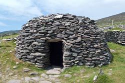
Beehive Hut |
Noteworthy:
For the most part I followed the official Dingle Way route. However, there were several alternate paths I chose to walk, and often these were a day's highlight. The following is my noteworthy list where reference to these diversions are identified by waypoint ID, e.g. (A129-A134) Gallarus Oratory.
• On my walk from Camp to Anascaul, I diverted to Sammy's Cafe along Inch Beach, (A009-A015), a place where I had relaxing lunch overlooking the wild and wicked surf. This locale was one of the beaches (along with Slea Head) where in 1970 the movie Ryan's Daughter was filmed, a story which takes place in an isolated village on the Dingle Peninsula during WWI. I still remember the stunning cinematography of that fabulous and treacherous, Oscar winning, night scene with the beach landing of numerous oar-boats.
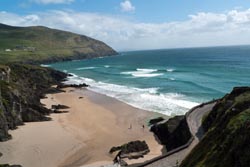
Coumeenoole Beach near Slea Head |
• Dingle was a delightful town to visit. It boasts some 60 plus pubs and has numerous excellent restaurants. At Doyle's Seafood Restaruant I savored my best meal while in Ireland. I had a layover day while in Dingle, and I had hoped to take the ferry to the nearby Great Basket Island, but foul weather meant the ferries weren't running. Rather, I walked around town visiting shops in full rain gear, and was happy to know that I was not walking the track.
• On my walk from Dingle to Dunquin, I diverted from the main route walking along R559 rather than the higher ridge track so as to visit Fort Dunbeg and the Beehive Huts, (A082-A090). Near Fort Dunbeg I took a well deserved lunch break and discovered The The Stonehouse Cafe, (C083), enjoying its relaxing atmosphere and excellent food. Later that day I explored Coumeenole Beach, (A095-A097). I believe this beach was also used in the filming of the 1970 movie Ryan's Daughter as I had learned a few days earlier at Sammy's Cafe along Inch Beach.
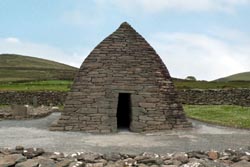
Gallarus Oratory |
• On my walk from Dunquin to Ballydavid I was treated, and let me make this perfectly clear, to my most favorite section of the Dingle Way. Near Clogher is a wonderful cliff walk (A018-A118) which rambles along the water's edge on pleasant meadowland. Later that day I diverted to view the Gallarus Oratory (A129-A134), a wonderful antiquity. Nearby were several other antiquities (Reasc Monastic Site and Kilmalkedar Antiquity Sites), but with too few hours in the day and too many kilometers already walked, compromises were made.
• The highlight of my last day of walk was a visit to the monument of 6th century Saint Brendan (A144-A146), see box below. The monument is near the Brandon Creek outlet, also worth viewing.
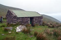
Sheep Herder's Cabin & Rain Shelter |
• It was not what I really hoped for on my last day of walking the Dingle Way over Mount Brandon. The route started at sea level, climbed 650 meters to the saddle near Mount Brandon, and then down again to the village of Cloghane and its idealic bay. It was just an average day, that is my recent Irish holiday average, of weather with lots of wind, cloudy skies, and threats of rain. The climb up was not difficult and the route was well marked, but the track was an endless bog. Up about half way what views there were disappeared in an endless sea of fog and mist. Further up the blustery winds changed to torrents and the visibility reduced to about 50 meters, but fortunately the wind was to my back. I was a happy man as I reached the saddle for then I expected the wind and rain and cold to subside as I descended, but of course it just got worse. My first clue of something amiss was the waypost at the top pointing in a direction that had to be over a cliff. Certainly that must have been a mistake, so I meandered over to the cliff edge only to find numerous wayposts lining the fall line on the other side. Oh shit! Thankfully, I was wearing full rain gear and gaiters, and had a good walking stick. While the track seemed deadly steep, the entire path down fortunately had adequate footing - the rocks weren't slippery and the mud was only boot top deep (but my gaiters handled that). Hurricane gusts of wind at my back often made me feel like I would fly (and die) on my journey down. I only slipped twice as the mud sometimes didn't hold, so my rain gear became patterned in brown and of course my gloves got trashed. Halfway down at about 300 meter elevation the track leveled off at the site of what appeared to be a sheep herder's cabin and rain shelter (C155). My day ended at O'Connors Bar and Guesthouse (C167) with a well deserved pint of Guinness and a fine dinner.
Cloghane Bay |
So you must now be asking yourself, do I dare tackle Mount Brandon? I too asked that question the night before as I was concerned about the weather. In retrospect, I would split the day from Dunquin to Ballydavid in two so as to enjoy more of the antiquities along this section of the route (such as Reasc Monastic Site and Kilmalkedar Antiquity Sites), and then end the walk before tackling Mount Brandon.
Lodging and Gear Transfer:
The best source for lodging and gear transfer along the Dingle Way is DingleWay.net. Rather, on my walk I used a service to organize my lodging and gear transfer, but I thought many of their choices deficient especially when I had needless 1-2 km walks off-track to lodging when on-track lodging was readily available. I therefore cannot recommend that service, Footfalls Walking Holidays. There are, of course, many other services which can arrange Irish walks, and if you choose to use one of these I suggest that you confirm that the lodging they select for you is near village centers where an assortment of bars and restaurants might be and that the lodging is also nearby the walking track.
From my walk I can recommend three lodgings:
* Finglas House located on the track in Camp.
* O'Connors Bar and Guesthouse located on the track in Cloghane.
* Although I didn't stay here, I did enjoy a fine dinner at Gorman's Clifftop House near Ballydavid and believe it would be an fine place to stay.
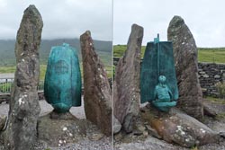
Monument to Saint Brendan As posted at the monument: St. Brendan, Patron Saint of the Diocese of Kerry, was born in the year 484 AD. Tradition has it that together with 14 monks he planned to bring the Gospel to the unknown Continent to the West. Having prepared, by Prayer and Fasting, for forty days on Mount Brandon, he set sail from Brandon Creek around the year 535 AD. It took seven years for the monks to reach America across uncharted waters. The story of his voyage is recounted in The Medieval Manuscript "Navigatio Sancti Brendani Abbatis." St. Brendan died at Annaghdown, County Galway in the year 578 AD and is buried at Clonfert, County Galway. St. Brendan described his route as via the Isle of Sheep, The Paradise of Birds, The Isle of Smiths, The Land of Crystal Pillars, Through the Region of Fog to the Promised Land. 1400 years later Tim Severin recognised these 'Stepping Stones' of his route as The Hebrides, The Faroes, Iceland, Greenland, Newfoundland and America. |
Google Earth:
When planning your trip, you may find it useful to view the path via Google Earth (a free software download). With Google Earth, you can upload the *.gpx waypoint file to view the terrain. If you plan to customize the waypoint list, Google Earth is a valuable tool.
Customized *.gpx Files:
For the adventurous you can modify the waypoint list to create your own *.gpx GPS waypoint file or a new *.pdf guide file or a new *.txt report file. The author created a Windows command line utility called makegpx.exe. It converts a text file with lines of space/tab delimited {WaypointID Longitude Latitude [OptionalElevation] Description} into a *.gpx file and/or *Guide.pdf file and/or *Report.txt file. Click here to get this tool.
Notes and References:
The Wildtramper would like to thank those who preceded him to help generate this waypoint file. Hopefully this version will find wide acceptance and some future trampers will improve upon this work.
1) Much of the primary reference for waypoints were track files obtained from WikiLoc.
2) A description of Irish Grid can be found at Ireland's Ordnance Survey.
3) Elevations were extracted from Google Earth.
4) The accumulated distance values in the table was obtained by first using the Irish grid northing and easting values along with the Google Earth's elevation to generate (x,y,z) coordinates. The distance between these coordinates were then calculated and accumulated. The result yielded a total distance of about 9% less than the expected. Hence, the values in the table were then tweaked higher.
5) The % incline values in the table was calculated as the straight line slope between adjacent waypoints. Because the waypoints are often distant from each other, the incline values are at best approximate. Large incline values, certainly those greater than 15%, generally mean steep slopes and maybe a path between the waypoints with zigzags or switchbacks to make the elevation gain or loss more tolerant.