Click c2Waypoints.pdf for a PDF copy of this report, OR click for my Coast to Coast 2016 Path Report, OR click for my Coast to Coast 2010 Path Report.
Coast to Coast Path Waypoints & Take-Along Guide
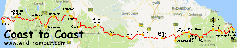
This report describes a comprehensive set of GPS waypoints, a hard copy guide (called the Take-Along Guide), and a set of tools to build a customized set of waypoints for England's Coast to Coast Path. The GPS waypoints and the Take-Along Guide described herein should be used in conjunction with a set of Ordinance Survey of Great Britain (OSGB) maps of the path so as to allow you to easily navigate, and to gracefully recover when navigation errors occur, as they will.
Of course a good quality GPS is important. On my walk I carried a Garmin eTrex 30 GPS that was always attached to my daypack strap for easy access and was always turned on. In addition to the GPS and OSGB maps, I also carried the Take-Along Guide (described herein) to reference GPS waypoint IDs with directional instructions. I found the combination trustworthy, it kept me on track and helped me to quickly return to path when I misstepped.
The waypoints described here identify the main route, numerous alternate paths, and many points of interest. This version of waypoints has been updated from walking the Coast to Coast in 2016, while I also walked the path in 2010. Waypoint ID prefixes are used to identify various features of the path. Specifically the primary C2C path is identified with waypoint IDs of Cnnn (where nnn is a 3-digit number), while common alternate paths are similarly annotated as Annn or Bnnn or Dnnn, while points of interest are Pnnn, and lodging is Hnnn, and restaurants and pubs are Fnnn. Also, this version uses unique GPS symbol icons to more easily demark alternate paths and points of interest from the main path. This version includes descriptions with heading directions such as N (north), S, E, W, and also includes elevations. This version provides a hard copy of pertinent waypoint data that can be used as a Take-Along Guide for use with your GPS.
About the Files:
|
File |
Description |
|
How & where to get |
It is recommended that these files be downloaded using your browser's save link as option rather than just clicking on the link. The files are available from the website of www.wildtramper.com. |
|
All of the following files packaged into a single *.zip file. |
|
|
This file. |
|
|
GPS waypoint file for England's Coast to Coast path. This set includes more than 750 waypoints with a bit more than 500 waypoints along the primary path, about 150 waypoints along about 20 alternate paths, and about 70 points-of-interest waypoints. |
|
|
c2cWaypointsGuide.pdf
|
A consolidated waypoint list which is intended to be printed double-sided, then clear-plastic laminated, and then sliced into 2 inch wide columns to be used as a Take-Along Guide for use with your GPS. |
|
A readable text file of waypoints and miscellaneous information. It is a spreadsheet which can be imported into MS Excel. The tab-delimited report has column heading: # (reference number), WP (waypoint ID), WGS-Lat (WGS-84 latitude), WGS-Lon (WGS-84 longitude), Elev (elevation), OSGB-Grid, Miles (accumulated miles), Grade (approximate % grade), and Description. |
|
|
The primary waypoint input data which is used by software utility makegpx.exe to create: (1) GPS waypoint *.gpx file, (2) Waypoint report (text) file, and (3) Waypoint PDF Take-Along Guide. |
Details:
All total, this waylist version for the Coast to Coast Path includes more than 750 waypoints: 500+ along the main route, about 20 alternate paths comprising 150+ waypoints, and 60+ waypoints demarking points-of-interest. In addition to the GPS *.gpx waypoint file, a PDF file of handy waypoint information makes a useful Take-Along Guide to supplement the GPS. It is intended to be printed double-sided, then clear-plastic laminated, and then sliced into 2 inch wide columns to be carried for as quick reference with your GPS.
The GPS waypoint file is called c2cWaypoints.gpx. It uses several categories of IDs represented by unique GPS icon symbols: Main C2C route waypoints (Cnnn) are identified with a red flag, alternate Annn path waypoints with a green flag, alternate Bnnn path waypoints with a blue flag, alternate Dnnn path waypoints with a red pin, points-of-interest (Pnnn) waypoints with a medium-city icon, food (Fnnn) by a bar icon, and hotels and B&Bs (Hnnn) by a lodging icon. On the walk from Kirby Stephen to Keld, the red, blue, and green flags coordinate with the red, blue, and green routes. Points-of-interest may be historic such as P166: Another Stone Circle or P248: Ruins of Crackpot Hall, or certain on-route eating/drinking establishments such as P388: Lord Stone's Cafe or P276: Ice Cream Parlor, or various lodging which the author used.
WP |
Grid |
Elev |
Description |
Take-Along Waypoint Guide |
C001 |
NX9615 |
8 |
St Bees - Start of C2C |
|
P001 |
NX9743 |
53 |
Fleatham House, St Bees |
|
C002 |
NX9456 |
23 |
Fleswick |
|
P003 |
NX9412 |
89 |
St Bees Lighthouse |
|
C003 |
NX9410 |
57 |
Bear R, follow coastline |
|
C004 |
NX9565 |
97 |
Quarry bungalows, head S |

Although GPS *.gpx files are specified with the WGS-84 (World Geodetic Standard, 1984) datum in decimal-degree longitude-latitude, the table of the Take-Along Guide uses the OSGB-36 (Ordinance Survey Great Britain, 1936) grid system to coordinate with hard copy maps of the Coast to Coast Path. Therefore, you should configure your GPS to the OSGB grid system. Additionally, when you arrive at the start of the Coast to Coast Path, you should instruct your GPS that this is a new location so that it can synchronize with the satellites as fast as possible.
The table for the Take-Along Guide identifies the waypoint path in four column slices. The first column identifies the waypoint ID (WP) followed by the accumulated distance in Miles. The second column identifies the OSGB Grid to a resolution of 10x10 meters. The third column identifies the Elevation in meters as extracted from Google Earth followed by a very approximate +/- % incline, so an incline of say 2% relates to a gentle rise in elevation, while an incline of say -30% implies a very steep loss in elevation probably with zigzags along the path down such as A091,-31%: Turn L, winding descend. The forth column is a Description. From the example table, waypoint C001 identifies the start of the C2C, while waypoint P003 highlights the point-of-interest St Bees Lighthouse, and waypoint C004 indicates you have walked 3.7 miles along the route and that the incline is about 2%.
The description field is condensed, thus a few abbreviations are used. Heading directions are abbreviated as single letters of N, S, E, W or compound directions such as ESE. Turning right or left use letters R and L. While w/ means with, e.g. C197: Bear R w/wall on right interprets as Bear right with wall on right.
Alternate Paths:
When I walked the Coast to Coast Path I sometimes chose alternate paths. The waypoint file c2cWaypoints.gpx contains many such alternatives, some are long and complicated while others are simple short cuts. The able which follows describe all alternate paths.
|
Set |
Waypoint IDs |
Description |
|
1 |
A033-A034 |
Scenic, but steeper, path down Dent summit |
|
2 |
A055-A068 |
Red Pike, High Stile, High Crag, Haystacks |
|
3 |
A082-A092 |
Half Crag, Gibson Knott, Helm Crag |
|
4 |
D092-D093 |
Path to Oak Bank Hotel in Grasmere |
|
5 |
A095-A097 |
Tongue Gill (rather than Little Tongue Gill) |
|
6 |
A100-A110 |
Dollywaggon Pike, Nethermost Pike, Helvellyn, Red Tarn |
|
7 |
B100-B107 |
St Sunday Crag |
|
8 |
D106-D109 |
Path to Grisedale Lodge and to Ullswater Steamer in Glenridding |
|
9 |
B120-B125 |
How Town Steamer landing to stone circle at P126 (then follow A126-A134) |
|
10 |
A117-A134 |
Pooley Bridge Steamer landing to Crown & Mitre in Bampton |
|
11 |
B137-B142 |
To/return Crown & Mitre in Bamptom from/to main path (after Haweswater) |
|
12 |
A173-A174 |
Short cut to avoid very dull grass |
|
13 |
A176-A182 |
Bypass for Orton |
|
14A |
A225-A237 |
Green route between Kirkby Stephen and Keld
|
|
15 |
A248-A257 |
Low moors "river" route via Muker and Gunnerside |
|
16 |
B257-B267 |
Low moors "high" route from Gunnerside to Reeth (per Steadman) |
|
17 |
A258-A268 |
Low moors "river" route from Gunnerside to Reeth |
|
18 |
A303-A310 |
Route to Easby Abbey from Richmond |
|
19 |
A372-A380 |
Off track to Osmotherley and return via Cod Beck Reservoir |
|
20 |
A397-A400 |
Path from Wainstones to easy forest road to Clay Bank Top |
|
21 |
A461-A464 |
Side path to various Bride Stones |
Maps and Reference Guides:
• "Coast to Coast Path" by Henry Stedman is an excellent comprehensive guide of the path. It includes numerous hand drawn maps of the route with detail to local terrain. It has where to stay and eat and includes accurate maps of villages. It also includes various other information such as flora & fauna, weather, public transport, and the like. Although I recommend this book for anyone walking the path, the maps are not to scale and do not include OSGB reference coordinates, thus I found the maps often lead to confusion as to where you might be.
• Harvey's "Coast to Coast West" and "Coast to Coast East" polyethylene maps are continuous strips to 1:40000 scale. These maps identify both main and alternate routes. I found these maps useful to absorb a days journey, but the smaller scale and the large physical format I found cumbersome to use on the walk. I thus two-sided, color copied these maps onto letter size paper and then inserted the copies into a waterproof (Ortlieb brand) map carrier.
• My GPS was downloaded with Great Britian contour maps. Although these maps should be available through your GPS manufacturer, I chose to use free open source maps (from http://talkytoaster.info/ukmaps.htm) and I found these maps were both detailed and reliable.
Google Earth:
When planning your trip, you may find it useful to view the path via Google Earth (a free software download). With Google Earth, you can upload the c2cWaypoints.gpx waypoint file to view the terrain. If you plan to customize the waypoint list, Google Earth is a valuable tool.
Customized *.gpx Files:
For the adventurous you can modify the waypoint list to create your own *.gpx GPS waypoint file or a new *.pdf guide file or a new *.txt report file. The author created a Windows command line utility called makegpx.exe. It converts a text file with lines of space/tab delimited {WaypointID Longitude Latitude [OptionalElevation] Description} into a *.gpx file and/or *Guide.pdf file and/or *Report.txt file. Get this tool from www.wildtramper.com.
Notes and References:
The Wildtramper would like to thank those who preceded him in generating C2C waypoint files. Hopefully this new version will find wide acceptance and some future tramper will improve upon this work.
1) In 2010 my primary C2C waypoint reference was www.walkingplaces.co.uk/c2c/gps.htm. Its accompanying text file is documented by Tim, Australia, www.GottaGetALife.com. In brief, it says:
The waypoints in the accompanying file were apparently originally logged by John Ledger, and published on Guy Wilson's website. (www.guy-wilson.co.uk/c2c.htm - which does not appear to be available any longer).
Subsequently they found "life" on the web at "Rick F's" website when "Canmal" - Malcolm compiled a GPX file from them after converting the co-ordinated to Lat/Long using a third party Spreadsheet. From there, they have been hosted on "walking places" thanks to "Lone Walker" at www.walkingplaces.co.uk/c2c.htm.
The general look and feel of the new waypoints is more or less the same as the original. However, many waypoint coordinates have been tweaked using Google Maps, Google Earth, and of course by walking the track. Also, most of the original descriptions have been enhanced, often to include heading directions.
2) Another set of C2C waypoints from www.billh.demon.co.uk/c2c/coast2coast.html was used in my original 2010 waypoints. While the primary reference comprises 514 waypoints formatted as a *.gpx file, this set comprises 517 waypoints formatted as a tabular text file. These two source are often identical, but they sometimes represent different options for alternate paths.
3) A description of OSGB-36 can be found from Great Britain's Ordinance Survey in a document titled "A guide to coordinate systems in Great Britain" with a subtitle of "An introduction to mapping coordinate systems and the use of GPS datasets with Ordnance Survey mapping," document number D00659.
4) Elevations were extracted from Google Earth.
5) The accumulated Mile values in the table was obtained by first using the OSGB grid northing and easting values along with the Google Earth's elevation to generate (x,y,z) coordinates. The distance between these coordinates were then calculated and accumulated. The result yielded a total distance of about 9% less than the advertised 190 miles (and this is not unexpected). The Miles values in the table were then tweaked to make the total main route distance exactly 190 miles.
6) The % incline values in the table was calculated as the straight line slope between adjacent waypoints. Because the waypoints are often distant from each other, the incline values are at best approximate. Large incline values, certainly those greater than 15%, generally mean steep slopes and maybe a path between the waypoints with zigzags or switchbacks to make the elevation gain or loss more tolerant.
7) The maps from Harvey's "Coast to Coast West" and "Coast to Coast East" are invaluable OSGB-36 grid maps, marking the main, typical alternate, and other paths along the C2C route.