
Click on NzReport.pdf for a PDF copy of this report OR read about my other New Zealand adventures in 2012 and 2008.
Herb's 2006 New Zealand Adventure
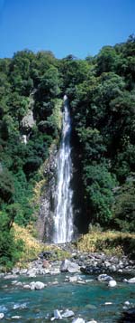 Mt. Aspiring NP
|
On February 1, I boarded a New Zealand Airlines plane which over the course of what appeared to be overnight crossed the international date line to be time traveled forward one day, however, a bit of mystical drama in fact transported me two score and ten years to the past. It had to have been, there was otherwise no explanation of the good times I had, the wonderful sights, and the always cheery, smiling, helpful, and just plain fun Kiwis of New Zealand.
Certainly a grand adventure, it was a bit more than five weeks. Spent entirely on the South Island, my main interest was tramping with numerous side trips via a rented car. Besides the landscape, what made the multi-day tramps special was the bonding with the same people over and over again - and it was on two occasions I later met the same fellow trampers. All the Kiwis were great, the ones on tramps had wonderful stories and the ones in town were always there to help with a smile. Food might have been the weak spot, it is British-ish consisting of more meat than I prefer, but I often found selections of local fish or pasta or salads more suitable to my palate.
This report is ordered from the best to the mundane, so you can stop at anytime if it gets too boorrrrrring. The last page is my final itinerary complete with costs and phone numbers along with a few comments. Mostly I stayed at B&Bs, private room with bath down the hall, and all these were fine. I also stayed at some backpackers, some less than tolerable. On tramps, I stayed in huts with lots of other people and neighborly sleeping arrangements, this was part of the New Zealand experience.
My itinerary in brief was: February 1, flew from SFO to Auckland to South Island, four day Queen Charlotte tramp, flew to Dunedin, rented car, saw yellow-eyed penguins, drove south catching ferry to Steward Island for two days (a day tramp & a DOC [Department of Conservation] guided tour of nearby Ulva Island), traveled to Te Anau for a four day Kepler tramp & a two day kayak trip in Doubtful Sound of Fiordland, traveled through Mount Aspiring National Park, up west coast stopping at Haast, Okarito, & Punakaiki, then to Motueka near Abel Tasman for a few days (a day tramp & day kayak trip), returned car in Nelson, to Collingwood for the Farewell Spit tour, a five day Heaphy tramp, return to Nelson, and then home to SFO on March 10.
The Best
• Best Place: The village of Okarito is on the West Coast, is 16 km off route 6, and has a population of (I guess) 50. It is very secluded, has neither food nor restaurants, but is an absolute peaceful place nestled next to the Tasman Sea and the Okarito Lagoon. I wished I stayed two nights rather than one. With lady luck timing upon arrival, I tramped 4 km down the beautiful beach at low tide to watch and listen to the wild and wicked surf of the Tasman Sea, and then returned 4 km through the bush of the hills adjoining the beach to view birds. The nearby lagoon would have been an fun place to kayak or just walk to view the abundant birds if I had an extra day. An ornithologist I met twice, first tramping on the Kepler and then later on the Heaphy (small world), agreed it was a grand place for birds.
 Routeburn Track
|
• Best Tramp:The Routeburn day tramp (from Glenorchy) to the Routeburn Falls Hut was easily my favorite. The track climbed through a lush forest over easy to walk peaty soil, over several flowing creeks with swing bridges, to a high meadow, and then to an alpine area with views of steep, jagged, granite peaks. The night before a dusting of snow fell on the peaks, adding to the grandeur. Originally I had planned to do the Grand Traverse as it is called comprising the entire Routeburn track and picking up the Greenstone to make it into a loop, but a few days earlier I had an embarrassing moment while at a hut on the Kepler track where a bench fell on my toe, nearly breaking it (ouch!), thus putting me out of commission for a short while. So I can only imagine the alpine lakes and such further along the track. My next visit to NZ will definitely include the Grand Traverse.
• Best Kayak Trip: An overnight kayak trip in Doubtful Sound was simply spectacular. Incessant rain on the first day brought the fiords alive - oddly the rain is what you want. Fiordland is glacier carved granite with near vertical walls, it has but a thin layer of soil to support its dense vegetation. Here you can see evidence of tree-valanches where a swatch of soil gives way laying bare what use to be dense foliage. A plethora of water falls, some reaching 500+ meters were a delight to view up close and sometimes personal - we kayaked under some of the falling water, it was a real cool blast. The rain but not the wind let up somewhat the second day creating a totally different Fiordland experience. Near the end of the trip, we paired the tandem kayaks and hoisted sails for a fast and fun and sometimes wet ride back to our start. By the time the trip was complete, my upper body was complaining for vitamin-I (ibuprophen). Guided by Fiordland Wilderness Experiences, they provided an outstanding guide, expedition tandem kayaks, wet suits and other essential cold weather gear, tents, cookers, and at our campsite a large bug tent with chairs, they even had a toilet. At 2 AM in the morning I heard the call of a kiwi, it went ki-WEEEEEE ki-WEEEEEE, it was a great awakening since kiwis are nocturnal and are difficult to observe. There was no additional charge for the incessant sandflies in such large numbers that they seemed to live on insect repellant, an experience once had you will never be bothered by sandflies in normal numbers again - but fortunately they didn't like the toilet so solitude in its rawest from could be had!
• Best Drive: The short 50 km drive along route 6 through the northern corner of Mount Aspiring National Park was awesome. As with all of Fiordland, the terrain is nearly vertical glacial carved granite with lush vegetation. The day I drove through there was no rain, but still there were plentiful water and waterfalls. A variety of tracks pepper the roadside for opportunities to view the landscape in more detail. Fishing opportunities abound. Had I known, I would have allocated a full day for this area.
• Best Kiwi Tale: Although everywhere in NZ I enjoyed the polite laid-back style of the Kiwis, but when on Steward Island I tried to book the DOC guided tour to Ulva Island to view native birds. It was 5 PM and the DOC person said they needed four for the next morning's trip, that I was the first, and that they close at 7 PM. So I decided to go to plan B - have a beer and decide later. At 6:30 PM I was at a pub having another good beer with dinner when the staff approached me asking "Are you Herb? You have a phone call." My first thought was somebody died, but I realized that absolutely nobody knew I was there. The phone call was from the DOC center explaining that they had three others looking for a forth for the Ulva Island tour. Only in NZ would someone phone all the lodgings asking if they had a tall, single, male, American in a red T-shirt. When they knew my name, they started calling all the pubs until they found me. So the next morning I very much enjoyed the expertise of the DOC guide to Ulva Island.
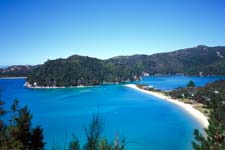 Torrant Bay, Abel Tasman NP
|
• Favorite Feathers: It was 5 AM, we were ready to go, that is myself, another early bird, and our guide. Near Dunedin we were heading to the beach at Sandymount Wildlife Refuge on the Otago Peninsula to reach a blind to view the yellow-eyed penguins on their daily march down the hill to the ocean at day break. That morning (2/10) we viewed nine penguins, two of which were recently fledged juveniles. The juveniles were easy to spot since they didn't have the characteristic yellow-eye patch, but more distinctly they weighted more than the adults as obvious by their bottom heavy shape. The highlight was one of these juveniles who we believe made its first trip down the hill and first swim in the ocean. The hill was moderately rocky and steep and was well used by the penguins. The adults easily maneuvered the hill, waddling and hopping their way down. Our favorite juvenile would occasionally misstep and have a cute falter. The adults usually went down in mating pairs to the ocean, and once at the waters edge they swam like a rocket to be seen only momentarily when they surfaced to breath. Our favorite juvenile was just like any kid swimming for the first time, it didn't want to get its head wet. So with craned neck it tried swimming the surf to no avail. It quickly learned to keep its head down, but it had much too much buoyancy to swim effectively and when its wings flapped, it only splashed and flailed. This it did for 20 to 30 minutes when we lost sight of it. Our guide said that it would repeat this outing for several days until it both learned to efficiently navigate the water and to loose those extra pounds, and then formally hunt for food. An absolutely cute experience. Honorable mentions for favorite feathers were the Royal Albatross Center near Dunedin and bird watching near Okarito.
• Favorite Hut Locale: Although none of the huts I stayed at were great places, it was the location of the Heaphy Hut at the terminus of the Heaphy River with the Tasman Sea that was special. Sandy beaches on both the river and sea made walking the area grand. As with all of the Tasman Sea beaches, its surf is wild and wicked, and it is totally unsafe to swim. It was easy to see the enormous rip tide created by the sea, and one must be careful even when standing near the water's edge from the periodic rouge wave that shoots inland rapidly. But this danger was part of its beauty. The Heaphy River is fairly substantial thus making the area at the sea junction most interesting. The river too has rouge waves that shoot up the terminus which can easily catch a lazy beach walking soul. Further upstream, the waters are more calm and are swimmable although somewhat cold. This was a great place to meander after dinner around sunset, everyone at the hut did so.
• Most Outrageous: Move over Burger King, Wendy's, and McDowell's, here comes the Kiwi Burger. I don't know what prompted me to order this, I guess I was hungry after a long day of tramping, not to mention the limited menu in Glenorchy. It consisted of a large greasy hamburger paddy, several slices of cheese, layers of fatty bacon, greasy grilled onions and mushrooms, lettuce and tomato, mayonnaise, all on a toasted bun - and not to be out done it also had a fried egg between the buns and it came with a large helping of chips (a.k.a. fries) on the side. Icky icky.
My Trip
Listed in order of occurrence are places and activities. Unless lodging or food was special, those comments are left out, but there may be comments in my detailed itinerary.
Queen Charlotte Track: A plane flight from SFO to Auckland to Blenheim and then a water taxi from Picton to Ship Cove in Marlborough Sound starts the Queen Charlotte tramp. Four days covering 71 km (i.e. 15+12+23+21 days) with nights at resort hotels, good food, and a daily water taxi shuttle of baggage - this made for a lazy start of tramping at the beginning of my New Zealand adventure. The first day was certainly the most scenic starting out at historic Ship Cove where Captain Cook anchored several times on his voyages to chart New Zealand. The track typically travels along the ridge providing periodic views of the sea below. But in my opinion, even without a heavy pack, this tramp was more difficult than the others since the track seemed to always go up or down, much like the trails of Henry Coe if you are familiar. None-the-less, an enjoyable four days.
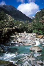
 Swing Bridge on Kepler Track
|
Dunedin: A nice larger coastal town reminiscent of a small San Francisco. Built on steep hills, the architecture is strongly Victorian. Because it is also a university town, it hosts a large variety of culture and restaurants, most all ethnicities. The downtown area had at least two outdoor shops which allowed me to stock up on camp stove fuel and other things as needed for later tramps. My first day I stayed in town and the second day at the Nesbit Cottage B&B for an all day Nature Guides Otago tour of the area one day and the next morning a view of the yellow-eyed penguins (described as Favorite Feathers above). Some of the all day tour gave a history of the town, but most was devoted to the Otago Peninsula for bird watching. The tour ended with a trip to the Royal Albatross Center, it was first class.
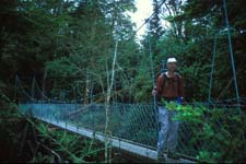
Steward Island: A 1-1/2 hour ferry ride from Bluff brought me to Steward Island. The small community at Half Moon Bay is the hub to the islands activities with various lodging, a grocery store, and several place to eat. After stopping at the DOC center to learn my options for the next two days, I decided to tramp (20 km) the next day to Maori Beach and then return via Garden Mound. The start of the tramp was monotonous because it was over the town's surface streets. Upon reaching the track, the scenery picked up and the walk followed the water's edge. About halfway to Maori Beach there was an alternate track which is used at high tide, but I chose the pleasant beach walk. At Maori Beach, I met the DOC warden doing her day's chore (painting), it felt like old times when I do volunteer work to help prepare our ski huts for winter. At the end of the beach was the first swing bridge I crossed while in NZ. Some swing bridges I've been on previously gave me the creeps, but the ones in NZ were well designed. They were all identified as to a capacity of 1 or 2 or say 5 persons, the smaller ones had perfect width so as to allow you to hold onto the guy wires, all had good footing, and all had netting at the footing edges to give you a safe feeling just in case you slip. Over the next few weeks, I would cross more than twenty of these swing bridges of various lengths and heights. After a relaxing lunch on the beach, I returned. By this time high tide had rolled in and I was forced to take the alternate route around a beach, it was less than pleasant - straight up through the bush and mud and muck and then straight down through the same, but this is part of the NZ experience. I chose a side trip to Garden Mound which took me up for a delightful view of the water front. After I got back, showered and cleaned up, I decided I would sign up for the DOC guided tour to Ulva Island the next day. It was this endeavor which set off the only in New Zealand chain of events described above as my Best Kiwi Tale.
Ulva Island: Ulva Island was a seven minute ferry ride from Steward Island. Unlike most of NZ, it has been declared pest free so that the birds (many of which are flightless) may thrive and multiply. Years ago, while the earth was still presumed flat, NZ didn't have any mammals other than man on the islands - no rats, no mice, no stoats, no deer, no pigs, none of these. With the advent of the round earth, shipping transported many of these rodents as unwanted passengers to the islands and others were purposely introduced for either sport or food or some birds because the English thought they were cute. So in many places, NZ has made a concerted effort to eradicate these pests. It was quite informative and enjoyable to have a DOC expert identify the various birds on Ulva Island. We didn't walk very far, but there was plenty to view and lots to learn (of which I forgot most by now). The trip, like so many of the guided trips I was on, ended with hot drinks and biscuits, it's the NZ way and quite pleasant at that.
 In the Love Boat, Abel Tasman NP
|
Intercargal: The return from Steward Island was uneventful for me, but not for others. A storm was brewing, and the 1-1/2 hour ferry ride back was through seas with 2 meter swells. Upon reaching Bluff again, I picked up my car and traveled to Intercargal, and lodged at a place with laundry facilities. The next morning I did shopping for some personal items which needed replacement, and I must say I certainly did get excellent assistance in NZ, it is like time traveling back to the 1950 in the States.
Riverton: I chose the scenic route to Te Anau, my next adventure center. On the way was the town of Riverton, and very nice indeed. By this time, the skies were clear and the weather was warm, so this southern coastal town was at it peak. I had two very good meals in this area, the first was a lunch at the Beach House Cafe which overlooks the bay, and that evening I traveled to nearby Colac for dinner at the Colac Bay Beach Bar which overlooks the Foveaux Strait to Steward Island. The time in between, I strolled the beach which, rather than sand, had silver-dollar sized cobble stones reminiscent of the Riviera - maybe that is why Riverton is advertised as the Riviera of NZ. Although not quite as serene as Okarito, Riverton is definitely one of my favorite locales.
Te Anau: Te Anau is my favorite tourist town, adjoining the lake the town is named after. It is relatively small, has a wide variety of restaurants, and is a hub for a multitude of adventure activity. Besides the power-@#%$ stuff I don't do, Te Anau is adjacent to Fiordland, is the starting point for the Kepler track, was my base for the Doubtful Sound kayak trip, and could have been my base had I chose to do the Milford track. The shortcoming to the town is you really need to have advanced lodging, otherwise you'll either pay top dollar or stay at one of the backpackers. Of my four nights, I had advanced reservations for two and stayed at a backpackers another two, and lucky for me this was a very nice backpacker's place. The day of my arrival the sky let loose with rain, so I thought I'd see a movie to kill some time. The theater was something that could only survive in Te Anau - the seats were wide and comfortable like airline first class, each had its own private table, and they concessioned (of course they did) beer and wine and real food. In the middle of the movie they inserted an intermission, half the audience (including myself) went out for refreshments. I learned the theater was originally build to show an up close and personal film of Fiordland which was shot by the owners. I later saw this nice feature, but I have to say that experiencing it by self was much better when I tramped the Kepler and Routeburn and especially when I kayaked Doubtful Sound.
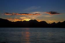
Kepler Track: Four days covering 67 km (i.e. 14+19+17+17 days) with stays at three huts. The first day had the most gain, about 900 meters (to elevation 1150 m), which starts along Lake Te Anau through forest on excellent track, and then climbs steadily past some limestone bluffs and then above tree line to open views of the lake and its South Fiord arm. The Luxmoore Hut was soon reached and provided commanding views of the region below. This was the largest hut I was at, it slept 60, but was very well laid out, and had flush toilets. It also had a large dining hall with banks of cookers and lighting. The second day was the most difficult, but I still rank it as moderate. On this day, there were many clouds hanging over the ridges where I would traverse, moderate wind, but no rain. The path of the second day rose to a long ridge walk (at 1450 m) with a pair of warming huts separated by about two hours distance from each other. Whereas the first day was advertised at 5-6 hours but took 4-1/2, the second day was advertised at 6 but took 6-1/2. Once on the ridge, there were commanding views most of the time in all directions, views at times of Lake Te Anau and then of Lake Manapouri. After the second warming hut, the ridge descended rapidly via sets of many, seemingly endless, stairs until tree line was reached, and then a long series of switchbacks through forest to the Iris Burn Hut (at 450 m). Although this hut was nice, it didn't have the commanding views of the Luxmoore or the serenity of the next day's hut. In the dining hall of this hut an embarrassing thing happened, one of the benches fell over onto my big toe and since boots are not allowed inside the huts, it created quite a lot of pain. By the next morning I wasn't sure if the toe was broken, but with the aid of Rita (a nurse from Germany on the tramp) and others, all agreed it was only a bad bruise. In any case, the damn thing hurt. Fortunately I had a good set of boots and after a trial run without my pack I concluded I could continue. The track to the next hut was easy even though it was 17 km away. So I took my time pampering my toe. When I reached the Moturau Hut, many of my fellow trampers gave me a cheer - how nice. The third hut was situated on Lake Manapouri complete with sandy beaches. It was a fine evening with whiffs of clouds in the far background and a colorful sunset. Sunrise was even better since the morning sun lit the mountains on the far side of the lake and the whiffs of clouds were still there to add to the early morning colors. My day out ended at the Rainbow Swing Bridge and then a bus shuttle back to Te Anau.
 Sunrise on Lake Manapouri
Kepler Track |
The Decision: With a bungled toe and my planned Routeburn tramp out of the question, I needed another activity. Well, Rita (the nurse) helped diagnose my toe, she also suggested an activity. Before her Kepler tramp, she did an overnight Doubtful Sound kayak trip. So rather than walk, I gave my feet and toe a break to sit on my arse and work my upper body.
Doubtful Sound & Kayak: I was fortunate that there was exactly one cancellation for an overnight kayak trip, I was especially fortunate that the cancellation wasn't for a three or four day trip since at the end of the overnight trip my upper body was really complaining. My destiny said try kayaking, but not too much, and that's how it turned out. The trip is described above as Best Kayak Trip. To get to/from Doubtful Sound, there was first a 45 minute bus ride to the docks of Lake Manapouri, then an hour boat ride across the lake, and then an hour bus ride over the pass to the base of Doubtful Sound. For what it's worth, Doubtful Sound got its name when Captain Cook was doubtful that his ships could sail in and out of its waters.
Glenorchy & Routeburn Track: Glenorchy is a small town at the northern end of Lake Wakatipu and is the gateway to many Fiordland tracks including Routeburn, Caples, Greenstone, and Rees Dart. The Routeburn and either the Caples or Greenstone tracks makes up a loop called the Grand Traverse, a trip I definitely plan for the future. I was also told that the Rees Dart Track is outstanding and is not nearly as crowded, it too is earmarked for the future. I stayed at the Glenorchy Hotel which was the locale of the best pub, although I've been told that nearby Kinloch Lodge is better. So with a toe that was slowly improving, I did a day tramp on the Routeburn, it is described above as Best Tramp.
Queenstown: Close your eyes and drive through for it isn't pretty, it was required passage to/from Glenorchy.
Mount Aspiring Drive: I left Glenorchy in the morning with plans to reach the west coast later that day. Had I known the drive through Mount Aspiring National Park was so nice, I would have spent more time. What I did see is described above as Best Drive.
West Coast: (Haast, Okarito, Punakaiki): My original plans called out for four days along the west coast, but although it was beautiful, the way I did it was monotonous. Next time I will spend multiple days in Okarito, described above as Best Place, and mostly skip the rest. I visited the usual tourist spots like the Fox Glacier, Franz Josef, Pancake Rocks at Punakaiki, but none of these struck enough interest to warrant a long stay. Only when I was off the beaten path in Okarito did I feel solace. So after two days on the west coast, I decided to drive directly to Abel Tasman so I could spend three rather than two day there. My nights on the west coast were at Haast, Okarito, and Punakaiki.
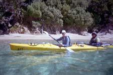
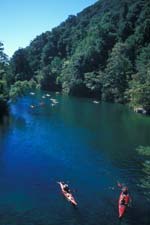
Motueka & Abel Tasman: Motueka is one of the gateway towns to Abel Tasman. It was a nice small tourist town with lots of lodging and many places to eat. Twice I ate at the Bake House across the street from the Info Center, I would eat there again - and they have a wicked cheese cake, a portion large enough for three. The bright spot of Abel Tasman is its stellar coast line, its weakness is a huge quantity of tourists. But like most places, tourists hang out at the edges, while remote locales are more secluded. My first day in Abel Tasman I took a water taxi to Bark Bay for a (20 km) day tramp back to the start. The track meandered in and around various coves and bays along the shoreline, often through the bush, but periodically with stunning views of the coastline below. The next day I was on a kayak trip organized by Kaiteriteri Kayaks, called their Soul Food trip. This trip had a 1-1/2 hour water taxi to its start at Mutton Cove where we had a day of easy paddling and then another water taxi back. Because of the remoteness of our start, there were few others around. We were all in tandem kayaks, I was paired with Tanya our guide, we were in a kayak named The Love Boat. At the beginning of the trip we visited a seal colony up close and personal complete with moms and cute pups. While we were there, the curious moms would follow the kayaks, something that the remoteness of our location allowed. Throughout the day we paddled in and around the granite rocks that dot the shoreline, Tanya guiding me to places I would probably not have otherwise gone. At noon, a water taxi delivered our lunch, and to a sandy beach we feasted. It was a very enjoyable day, although much too short. Compared with kayaking in Doubtful Sound with big lumbering expedition kayaks, this day was fun and easy and my upper body didn't complain. Although not on my Best Of list, Abel Tasman is certainly worth several days exploring, and you can't beat the always sunny weather.
 Kayaks
Abel Tasman NP |
Nelson: By this time my trip was reaching its last set of activities. From Abel Tasman, I drove to Nelson and dropped off the rental car. From here I used coach transportation to Collingwood, the next day the same coach transportation to the start of the Heaphy Track, and later returned to Nelson from the far end of the Heaphy track at Karamea.
Collingwood & Farewell Spit Tour: Collingwood probably survives today largely on the tourist trade from the Farewell Spit tours. No doubt it is a cute little town with nice beaches, but there's not much else. So early in the morning (6:45 AM) I took a coach from Nelson to Collingwood, that left me most of the day to walk the beach and to view the historic cemetery. The 6-1/2 hour spit tour was coordinated with low tide, and on this day it started 3 PM. Although you can visit the base of the spit on your own, only the tours are allowed to drive the 21 km to the sand spit end, using their beefed up 4WD buses. Along the way we viewed many birds and saw lots of sand dunes. I was told that the Abel Tasman side of the sand spit widens by 1-2 km at low tide, but we drove predominately on the Tasman Sea side. Driving the spit was interesting since the sand in places was unstable, thank goodness for experienced drivers. At the spit end was the light house. On the way back and because of the lateness of the day, we stopped by a sand dune for a few moments to enjoy the sunset.
Heaphy Track: Five days covering 82 km (i.e. 17+13+14+22+16 days) with stays at four huts. Rather than give a sequence of events, it is better to describe the Heaphy track in retrospect. That is, if I were to do it again, I would start from the south end near Karamea and maybe stay one night at the Lewis hut and definitely stay at the Heaphy hut. It was the walk along the Tasman Sea and the terminus of the Heaphy River at the sea which made this track special. The rest of the track was more mundane, the other huts were small and generally too crowded, the exception was the Gouland Downs hut which was delightfully cute with its large wood burning fireplace, no cookers, but only slept six. Although the Heaphy hut itself is nothing special, I thought its locale ranked in my best list as described above in Favorite Hut Locale. Late in the evening while at the Heaphy hut it started to rain, and by morning it was a full storm, so my tramp out from Heaphy was very wet. But with all that rain, the creeks became wildly turbulent with muddy water, it was a very interesting site. Most of the creeks had bridges (either wood or swing), but there were a few that only had well placed rocks to hop. About 2/3 of the way back, the sky cleared to a blistering blue so I got to enjoy some of the beaches and the wicked and wild surf of the Tasman Sea. A most interesting day. This was my only true test for wetness on any NZ tramp, and I have to say some of my methodology needs improvement. Those items in dry bags (such as sleeping bag and extra cloths) stayed dry, but even with a pack rain cover everything else ended up damp. It was nice that that evening I was at the Last Resort Hotel. The next day I traveled from Karamea to Nelson, and the following day flew from Nelson to Auckland to SFO. Certainly a grand trip that was much too short. I'll be back.
Next Time
• Routeburn/Greenstone & Rees Dart Tracks: Based out of Glenorchy are the Grand Traverse consisting of the Routeburn/Greenstone tracks (or optionally Caples for Greenstone) and also the Rees Dart track. These are all within Fiordland with its steep, glacial carved, granite and often lush vegetation. I had a taste of the Routeburn and would do the Grand Traverse on my next visit. The Kiwis recommended the Rees Dart track describing it as equally beautiful, but it is more primitive and thus has fewer trampers. This too I would do on my next visit.
• Lake Waikaremoana Track: An easy 4 day Great Walk on the North Island, it was recommended by several Kiwis.
• Tongariro Crossing: I am told this track is quite amazing, recommended by several Kiwis.
• Okarito: Assuming I travel the west coast of the South Island, I would spend at least two nights in Okarito, it was my favorite place.
Oddities
• Total distance tramped: Queen Charlotte (71), Kepler (67), Routeburn (day 20), Abel Tasman (day 20), and Heaphy (82) is 260 km = 155 miles.
• Great Walk Tramping: Normally I judge the amount of walking for a day by distance and elevation, but as with all of the Great Walks this metric doesn't quite work. It is because the Great Walk tracks are graded so uniformly that their difficulty is greatly diminished. So I recommend also using the time metric given in literature for track segments as well, and maybe even slightly less time than identified. When on non Great Walks, tracks are more rugged, thus making them more difficult.
• Estimated expenses: Flight+lodging+car+guided trips (see detailed itinerary last page) was $US4605. Estimated food+gas+miscellaneous brings total to about $US6000 for the 38 day adventure.
• Customs: Before passing through customs, make sure your hiking boots are absolutely clean, otherwise they will be washed for you.
• Car: Originally I didn't want to rent a car, but I did anyway. The freedom to be anywhere was well worth it. I certainly would never have traveled to Okarito without one. It took me about a day to get use to driving on the other side of the road, although I don't think it became instinctive, and I never drove at night.
• Camera: I took a small point and shoot film camera rather than my big SLR, I consider this a good decision. But after my overnight kayak trip, I bought an inexpensive waterproof camera for my second kayak trip. If you shoot film, always have it hand checked at airports.
Equipment
When in town I wore cotton Ts, when on the track I wore wool socks, silk shirt, nylon pants, bandana, and had both light-weight cotton cap or nylon rain hat. On multi day tramps I carried a nylon overshirt, 100-weight fleece shirt, silk bottoms, Gortex-like rain pants & jacket, wool cap, fleece glove liners, extra socks & silk shirt, small towel & extra bandana, and alternate footwear (e.g. neoprene booties) for the huts. Sleeping gear was silk sleep-sheet with 30° F down bag (too warm). Kitchen was a 24 oz Glad bowl, small titanium pot, lexan cup, and fork/knife/spoon - cooking only with boiled water but many Kiwis had more regular meals. My ditty bag always included insect repellant (deet worked well), sunscreen, and iodine. I saw no water filters, most Great huts claim water is potable but I always iodized my water. For foul weather, I used light-weight "Sea to Summit" dry bags for sleeping gear and extra clothes (worked great) and pack rain cover (didn't work well in the torrent). I recommend sturdy boots (they literally saved my once bungled toe), a walking stick, and sometimes I used half gaiters (for mud and to keep sandflies from traveling up the pant legs). I carried 1st aid & survival kits, and a small stiff bristled brush to clean boots from time to time. I used a 1-1/2 liter thru-the-straw Platypus drinking system (always adequate between water points). My luxury items were a small point-and-shoot film camera, voice recorder (highly recommended), and sometimes binoculars, and when kayaking an inexpensive waterproof camera.
Day by Day Itinerary and Expensives
| Date |
Day |
$4,605 |
Activity |
Description |
| 2/1 |
Wed |
1139 |
° Leave SFO @ 7:15P - NZ Air, Flight 7, flight about 13hr. |
|
| 2/2 |
Thur |
° Cross international date line |
||
| 2/3 |
Fri |
196 46 |
° Arrive Auckland @ 5:15A. Fly Auckland to Blenheim ANZ #2177 (11:15-12:45) $US196 ° stay Marineland Motels & Guesthouse B&B, VISA, $NZ65, 3-573-6429, 26-28 Waikawa (near Wellington). |
|
| 2/4 |
Sat |
49 53 |
Queen Charlotte |
° Water taxi “Endeavor” (45min) to Ship Cove, depart 9A, $NZ70, gear xfer/ pickup@Anikiwa, 3-573-5456. ° Queen Charlotte Track, stay Endeavor Lodge, $NZ75, 3-579-8381, cash-only, 15km, LowTide@7:21A |
| 2/5 |
Sun |
46 |
QC |
° same, stay Camp Bay, 12km, stay Mahana Homestead, $NZ65, 3-579-8373, LowTIde@8:01A. |
| 2/6 |
Mon |
21 |
QC |
° same, stay Portage, 23km, stay Portage Bay Shop, $NZ30, 3-573-4445, 2bed-shared, LowTide@8:45A. |
| 2/7 |
Tue |
46 |
QC |
° finish at Anikiwa, 21km, water taxi to Picton, LowTide@9:38A ° stay Marineland Motels & Guesthouse B&B, VISA, $NZ65, 3-573-6429, 26-28 Waikawa (near Wellington). |
| 2/8 |
Wed |
120 752 60 |
° Fly Bleinheim (to Christchurch) to Dunedin ANZ #2125-#5053 (12:10-2:45) $US120 ° Avis, compact-auto, $NZ1164, 3-486-2780 ° stay Albatross Inn B&B (continental breakfast), $NZ85, 3-477-2727, 770 George St, VISA, free internet |
|
| 2/9 |
Thur |
140 84 |
° Nature Guides Otago, 10A day tour of Otago etc (6hr), $NZ200, 3-454-5169, LowTide@8:44A ° stay Nisbit Cottage B&B, $NZ120, 3-454-5169, VISA |
|
| 2/10 |
Fri |
42 33 25 |
° Nature Guides Otago, 5A sunrise penguin walk (3hr), $NZ60, LowTide@9:31A ° flex - Travel to Steward Island, take ferry, $NZ47 ° stay Steward Island (at backpackers, not very good), ~$NZ35 |
|
| 2/11 |
Sat |
25 |
Tramp |
° flex - Stay Steward Island (at backpackers, not very good), day tramp to Maori Beach etc. (20km) |
| 2/12 |
Sun |
29 33 53 |
° flex - DOC tour of Ulva Island, $41 ° return ferry back to South Island, $NZ47 ° stay Intercargal, Best Western, do laundry, $NZ75 |
|
| 2/13 |
Mon |
39 |
° flex - Drive to Riverton ° stay The Riverton Rock Guesthouse, 136 Palmerston St, $NZ55, breakfast $NZ12, 3-234-8886, nice |
|
| 2/14 |
Tue |
67 |
° stay Shakespeare House B&B, Te Anau, $NZ95, VISA, 3-249-7349, 10 Dusky St |
|
| 2/15 |
Wed |
28 |
Kepler |
° Kepler Track, Hut=Mt Luxmoore, 14.1km, $NZ40 |
| 2/16 |
Thur |
28 |
Kepler |
° Same - Hut=Iris Burn, 18.6km, $NZ40 -- oops, smashed toe at Iris
Burn Hut! no 2/20-24 Routeburn tramp |
| 2/17 |
Fri |
28 |
Kepler |
° Same - Hut=Moturau, 17.2km. , $NZ40 |
| 2/18 |
Sat |
67 |
Kepler |
° Same - finish, 17.1km ° stay Shakespeare House B&B, Te Anau, $NZ95, VISA, 3-249-7349, 10 Dusky St |
| 2/19 |
Sun |
25 |
° stay Te Anau Lakeside (backpacker - ok place), ~$NZ35 |
|
| 2/20 |
Mon |
210 |
Kayak |
° Kayak 2 day, overnight, Doubtful Sound, $NZ300, excellent,
“Fiordland Wilderness Experiences” |
| 2/21 |
Tue |
25 |
Kayak |
° return, stay Te Anau Lakeside (backpacker), ~$NZ35 |
| 2/22 |
Wed |
60 |
° travel to Glenorchy, stay Glenorchy Hotel, $NZ85, (ok, maybe try nearby Kinloch Lodge) |
|
| 2/23 |
Thur |
60 |
Tramp |
° day tramp to Routeburn Falls Hut (18 km return), best hike, stay Glenorchy Hotel |
| 2/24 |
Fri |
77 |
° travel to west coast, thru Mt. Aspiring NP (very nice), more time in Mt. Aspiring NP would be nice ° stay Haast at Heritage Park Lodge, $NZ110 (lodging limited in area!!), do laundry |
|
| 2/25 |
Sat |
53 |
° flex - travel up west coast, stay Okarito (my favorite locale) at Kotuko
Lodge, 3-753-4151, $NZ75 |
|
| 2/26 |
Sun |
25 |
° flex - travel up west coast. stay Punataki at Nikau Retreat (backpacker),
$NZ35 (bad place, bad location) |
|
| 2/27 |
Mon |
37 |
° flex - skip west coast, travel to Abel Tasman, stay Motueka at Troubadour Motel, 0800-222-046, $NZ52 |
|
| 2/28 |
Tue |
19 37 |
Tramp |
° flex - tramp Abel Tasman, water taxi to Bark Bay ($NZ27) then return (20 km) ° stay Troubadour Motel |
| 3/1 |
Wed |
147 37 |
Kayak |
° flex - Kaiteriteri Kayak trip, “soul food” outing w/water taxi to Mutton Cove, great trip, $NZ210 ° stay Troubadour Motel |
| 3/2 |
Thur |
53 |
° Return car to Nelson ° Stay Nelson, Grove Villa B&B, 36 Grove St, 3-548-8856, VISA, $NZ75, contin-breakfast @6:15A |
|
| 3/3 |
Fri |
32 70 70 |
° Abel Tasman Coachlines, Nelson(@27 Bridge St, 6:45A) to Collingwood(9:30A), $NZ46, 3-548-0285 ° Cape Farewell Eco Tour (6-1/2hr), $NZ90, 3-524-8257, 3P-9:30P, $NZ10 lunch, LowTide@7:07P ° Stay Collingwood Skara Brae B&B (on Eliz St), 3-524-8464, $NZ100/ensuite, VISA, very nice |
|
| 3/4 |
Sat |
14 |
Heaphy |
° Abel Tasman Coachlines, Collingwood(9:30A) to Heaphy(10:10A) ° Heaphy Track, Hut=Perry Saddle, 17km, $NZ20 - (better hut is Gouland Downs) |
| 3/5 |
Sun |
14 |
Heaphy |
° Same - Hut=Saxon, 13km, $NZ20 |
| 3/6 |
Mon |
14 |
Heaphy |
° Same - Hut=MacKay, 14km, $NZ20 - (MacKay worst hut, Lewis is great hut, easy extra distance) |
| 3/7 |
Tue |
14 |
Heaphy |
° Same - Hut=Heaphy, 21.5km, $NZ20 - (very nice place, best hut and track from Lewis to end) |
| 3/8 |
Wed |
7 56 |
Heaphy |
° Same - finish, 16.5km, HighTide@6.28A+2.4, LowTide@11:51P+1.1 ° Karamea Motors shuttle, Heaphy @(1P or 2P or on call) to Karamea, $NZ10 ° stay Last Resort, $NZ80ensuite, 71 Waverley St, 3-782-6617, $NZ, VISA |
| 3/9 |
Thur |
18 25 53 |
° Karamea Express(3-782-6757): Karamea(7:50) - Westport(9:30), pay $NZ25 at Last Resort ° Kbus(3-578-4075): Westport(10:30) - Nelson(2:30), pay $NZ35 at Last Resort ° Stay Nelson, Grove Villa B&B, 36 Grove St, 3-548-8856, VISA, $NZ75, continental breakfast |
|
| 3/10 |
Fri |
104 |
° Fly Nelson to Auckland ANZ#8378 (1:15-2:35) $US104 ° Depart NZ Flight 8 @ 7P, SFO @ 10:15A. |