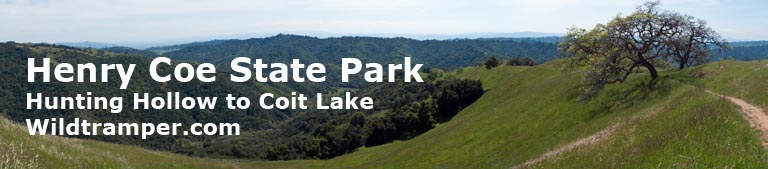
Henry Coe State Park
Hunting Hollow to Coit Lake ~ 13-15 April 2010
Background
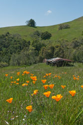
Flourishing Grasslands, Budding Oaks |
Northern California Spring is a time when Winter rains subside to leave way for Spring wildflowers. One of my favorite places to enjoy the Spring bloom is Henry Coe State Park, and I particularly enjoy a visit to Coit Lake. In April of 2010 I visited this area, my third such visit, the previous were also in April but in 2005 and 2009 respectively. I would follow a similar route starting at Hunting Hollow, climb the Wilson-Lyman trail to Wilson Ranch, then saunter down Wagon Road to the Crest Trail and Coit Road to my favorite campsite at Coit Lake's southwest corner, the luxury campsite with a picnic table, awning, outhouse, and spendid views of the lake. This report describes my three day trip. It also lists GPS Waypoints of my routes and it includes a copy of my report from my similar 2005 Coit Lake trip. You might also be interested in the picture book story of my 2009 Coit Lake trip. Click here for a PDF copy of this report.
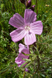
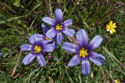
Checkerbloom |
Tuesday, April 13
It was the brilliantly bright green that carpeted Henry Coe that I will most remember about this outing. Winter rains were kind, while the recent storm of the previous two days made the creeks brimming with water. Now with a forecast of clearing skies, I was going to make home at Coit Lake, and on my layover day meander to Pacheco Falls.
I arrived at the Hunting Hollow parking lot at 9AM. Except for one other car, the large parking lot was deserted, and that car would still be there when I completed my outing on Thursday - I can only assume that that occupant was enjoying the backcountry. So with only one other car, I was hopeful to get my favorite campsite at Coit Lake, but that would be 9-1/2 miles and 6 hours later.
| |
|
The previous two days brought yet another Spring storm, and this one was impressive in a year with many such impressive storms. Rain totals for the year, I believe by this time, was 110% of normal, well above the scant rains of the previous year. But on this morning, the currently mostly cloudy sky was forecast to clear.
So at 9:30AM I was greased up with sunscreen in hopes of sunshine and was ready to go. After a short 30 seconds of walking I realized a misjudgment. Just as in 2005, another year of impressive rains, the Hunting Hollow creeks were running fast and full. So I stripped off my boots in favor of neoprene booties. I walked the first 0.7 mile crossing the creek six time in those flimsy things. The water, besides being cold, ranged from ankle to near knee-high deep. Fortunately, the moist and thereby somewhat spongy Hunting Hollow trail made it easy on the soles of my feet given that I had but 3/16" neoprene cushion for protection. After my sixth crossing I reached the base of the Wilson-Lyman trail, and there I replaced neoprene with leather.
Although steep, the best feature of the Wilson-Lyman trail is it gets most of the day's elevation gain over with in a hurry. The trail gains 1200 feet in 2 miles to the junction of the Bowl Trail, then an easy undulating mile to Wilson Ranch.
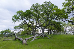
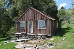
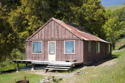
I've been to Wilson Ranch many times, and have always found it a nice place to rest and snack. But on this outing I was disappointed that the cabin had lost it's front porch. Years ago there was a chair or two on the porch to sit and relax, then they disappeared, and finally this year the porch too was gone. The beams supporting the porch and cabin looked dreadful.
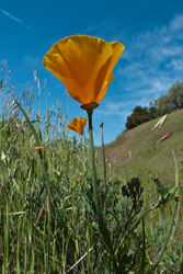
California Poppy |
With the porch off limits and relaxing in the tall grass undesirable because of the prevalence of ticks, I decided to kick back for a lunch stop on the nearby road. It was not what I had in mind, but it was certainly prudent. After lunch I filled my depleted water bottle from the nearby spigot, adding the necessary iodine to treat the water.
On the road again, literally. I had completed 4 miles (of trail) and had 5-1/2 miles (of dirt road) more to go. My path would take me along Wagon Road to the Crest Trail to Coit Road and finally to the southwest corner of Coit Lake.
From Wilson Ranch, Wagon Road rises and undulates from 2000 feet at Wilson Ranch to 2500 feet at the Crest Trail junction over a distance of 4 miles. Along the way I passed Grizzly Road and Wasno Road, both had those useful outhouses. It was a pleasant and easy stroll, it had panoramic views of spacious Henry Coe State Park to the north and east. The grass was blindingly green, not what I usually envision for the park.
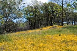
I turned onto the Crest Trail climbing another 100 feet to the antenna tower and then dropping 200 feet over about 1 mile to Coit Road. I always enjoy this section of trail with its numerous areas of wonderful wildflowers. Near the tower are often a plethora of California Poppies, while closer to Coit Road are areas carpeted in Goldfields, and in between are all the other usual wildflower suspects.
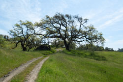
Wagon Road |
Reaching Coit Road meant I was close to my hopeful home for the next two nights, and as it turns out I got my favorite campsite. It was now 3:30PM, 6 hours on the trail of 9-1/2 miles with a lunch stop at Wilson Ranch and a break at Wasno Road.
The southwest corner of Coit Lake is my favorite Henry Coe campsite, a luxury site with flat ground for pitching a tent, a picnic table, an awning for shade, and a nearby outhouse. It is also a place with nice views of the lake while relaxing in my thermorest chair to read a book. The recent rains flooded some of the flat ground, but I found a good spot to put up my tent away from the always present ants - they seemed to also have reengineered their access hole and paths away from the wet.
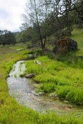
Normally Dry, Now Wet |
After setting up camp I did the all important tick check, and then relaxed a bit, and finally prepared an early dinner - I find an early dinner at this campsite beneficial because the warmth from the sun disappears by dropping below the nearby ridge crest to the west. After dinner I relaxed in my camp chair with a book, did another tick check, and then crawled into my tent to read a bit more before calling it a night. Temperatures that night dropped to 40°, cold enough for long underware and two pair of wool socks.
Wednesday, April 14
Although sunrise was at 6:30, I chose to snuggle in my warm sleeping bag until about 8:00 when the sun breached the eastern ridge crest to provide me with morning warmth. Of course by that time Coit Lake was buzzing with activity, the redwing blackbirds were flying and chirping and making their usual ruckus, although the ants were still hidden in their lair.
| |
|
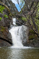
At 9:30 I was ready to explore, the sun was breaking up the few high clouds, it was going to be a stupendous day. In the past I circumnavigated Coit Lake along it's western shore to the dam and then onto the Coit Ridge Trail to White Tank Springs. At the tank I have often found spectacular and abundant wildflower displays. But with all the recent rain I didn't want to tackle the likely flooded western shore trail as was the case in 2005, a time when it was less wet than now. Rather my day would focus on Pacheco Falls.
My day's path would take me east on Coit Road (0.7 mile), then south on Wagon Road (0.2 mile), then north on the Live Oak Spring Trail (1.1 mile), then east on the spur trail to Pacheco Falls (0.9 mile). After the falls I retraced my path on the spur trail to go north again on the Live Oak Spring Trail (0.5 mile), then south on Coit Road (1.8 mile) with a few junctions in between, and back to camp. Elevation gain from camp (2133) was about 200 feet at the junction of Coit and Wagon Roads (2297), while elevation loss from there to Pacheco Falls (1312) was about 1000 feet.
Pacheco Falls |
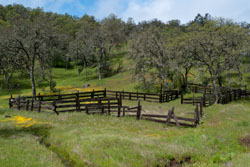
My first impression of my outing was more water and more green. Along Coit Road what is normally dry was now wet. Even the old ranch corral had a creek running through it.
Wildflowers were working their way towards procreation. Along the way there were numerous displays of my always favorite Goldfields. But I had the feeling that once the rains subsided and the sun dried out some of the wet that the full splendor of Nature's wildflowers would abound. Certainly a nice show, but another two or three weeks the backcountry would be a stunning display or as I said of my 2005 trip there would hopefully be an erotic orgy of interracial flower species prodigious in color and variety.
Pacheco Falls was gushing with water, the recent rains made for a dramatic display. The falls' pool rippled with excitement and drowned much of the usual vegetation and most of the track access. Access that was available was covered in very happy poison oak. It was a nice place to view, but not a place to relax and have lunch. Rather, I had lunch on the trail at the nearby trail junction above the falls. I nice break, but I would have preferred a lot less poison oak at falls' view.
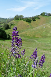
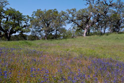
Lupine |
Poppies & Wilson Ranch |
Friday, April 15
Again I waited until 8:00 for the sun to breach the ridge crest for warmth before I tackled the morning. The skies were a brilliant blue, it was going to be a fine day. I had breakfast, packed up camp, put on plenty of sunscreen, and at 10:00 I was ready for my stroll out. I retraced my path back. With sunny skies, the wildflowers seemed to stretch their necks to bask in its rays. California Poppies opened their peddles, while many other varieties gleamed in the warmth, they all were enjoying the day and ready to procreate.
On the way back I noticed my inbound bread-crumb trail of boot prints now encased as a shrine to my journey. The often spongy road from a previous days was now baked hard like clay.
Along the way the hills were still bright green and flowers abounded everywhere. When I reached Wilson Ranch, the nearby hill was blanketed with now open California Poppies. The Wilson-Lyman Trail offered panoramic views and many places of floral excellence.
Once I descended to Hunting Hollow I noticed the creek level had diminished. I was able to easily ford the crossing nearest the Wilson-Lyman junction, but I again replaced leather with neoprene to ford the remaining five crossing, and unlike my walk with booties at the trip outset the hard ground was less kind to the soles of my feet. At 3:30 I was back at my car to a parking lot showing that many people were out enjoying the day. It was another grand trip.
Ithuriel's Spear |
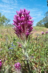
Owl's Clover |
April 2005 Coit Lake Outing
[Below is the report I wrote of my similar April 2005 Coit Lake outing].
Did I say it's wonderful out there, well it really was. I've never seen Coe in such floral excellence. I shortened the 3 nighter to 2 because of iffy weather (and justly so), so I had a day in to Coit Lake, a layover day with a day trip to Pacheco Falls, and a day out.
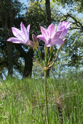
I can't get over the abundant green and abundant flowers. The bouquet really started getting grand once I was on the ridges, past Wilson Ranch on the way in. And as I progressed it just got better. Monday was overcast and breezy most of the day so the poppies closed their little heads in retreat. However, there were abundant Goldfields along the route along with Bird's Eye Gilia, Baby Blue Eyes, Owls Clover (and it's look alike cousin Tomcat Clover), Buttercups, Lupine, and much more. My favorite stretch was the Crest Trail, it was carpeted wall-to-wall with tender shoots of green grass and was chock full of flower varieties - the fact that it was a pleasant downhill slope near my final destination also helped. My hike in ended at the campsite near the Coit Lake inlet where there is a table, awning, flat ground, outhouse, and a nice rise above the lake to sit for gazing at the lake and to eat, read, and relax.
| |
|
On my layover day, I packed a few goodies for the day's outing to Pacheco Falls. I started by going north along the west side trail (often under water) along Coit Lake. Across the dam and onto the Coit Ridge Trail there were more flowers cavorting with Mother Nature. The creek near White Tank Spring was stunning with abundant water flowing among a myriad of flowers. Pacheco Falls was gushing with water, the large pool at the bottom rippling with reflected colors. This was a good place for lunch, although amid so much water and so much poison oak it was difficult to find a safe spot to sit. On the way out, I took the nearby side trail to view the falls from up above via a steep drop-off ridge where I saw three pools of water making up Pacheco Falls. Having a bit of acrophobia, I dared not venture any further.
Broadleaf Filaree |
On Wednesday, I took a route to make a loop for return. To Kelly Lake and up the ugly grade of the Kelly Trail but like my path in (up the Lyman-Wilson Trail) it completed much of the day's uphill early on. Wasno Road was another ridge with abundant flowers. With lots of sunshine, the poppies were all sun bathing. What was amazing along this route was the erotic orgy of interracial flower species, prodigious in color and variety - Poppies among Blue-Eyed Grass, Goldfields among Bird's Eye Gilia among Owl's Clover, and so on. Not just a flower here and there, but moderate sized fields. The roads seemed to be a haven for color. I even saw Blue-Eyed Grass mingled with white peddled Blue-Eyed Grass (so I think it was).
Past Wasno Road and onto the Jackson Trail, the floral display became more sparse, typical of what I normally think of Coe in Spring. Just after reaching Coit Road via the Anza trail I bumped into the first person since starting the trip - and a strange encounter it was. It was now 3:15P and he was heading into Kelly Lake to meet his father and son. He had a GPS on his pack strap and map in his hand, he showed me where he thought he was - somewhere along the Grizzly Gulch Trail. I corrected him and suggested the route I just took rather than backtrack to the awfully steep Grizzly Gulch Trail. I don't think he had a clue how long it would likely take, but everyone must do their own thing.
Directions & GPS Waypoints
The table below identifies paths and GPS waypoints (NAD27 datum) of my Coit Lake trip and nearby features. For a GPS data file of these waypoints, click on GpsCoitLake.gdb.
|
Category |
GPS |
Alt |
Waypoint |
Description |
Hunting Hollow to Coit Lake, 9.7 miles. |
10S636457 |
850 |
CAR LOT HH |
Hunting Hollow parking lot. |
10S637342 |
864 |
001 |
Junction Hollow Road with Wilson-Lyman Trail. |
|
10S639850 |
2092 |
002 |
Junction Wilson-Lyman Trail with Bowl Trail. |
|
10S640836 |
2034 |
003 |
Wilson Ranch. |
|
10S640997 |
2115 |
004 |
Junctions Wagon Road and Steer Ridge Road and Vasquez Road. |
|
10S640638 |
2090 |
005 |
Junction Wagon Road and Grizzly Road. |
|
10S640642 |
2285 |
006 |
Junction Wagon Road and Wasno Road. |
|
10S641156 |
2204 |
007 |
Junction Wagon Road and Center Flats Road to Dowdy Ranch. |
|
10S640922 |
2524 |
008 |
Junction Wagon Road and Crest Trail. |
|
10S640551 |
2500 |
JKELLYLKTR |
Junction Crest Trail and Kelly Lake Trail. |
|
10S639757 |
2184 |
009 |
Junction Crest Trail and Coit Road. |
|
10S640017 |
2215 |
010 |
Junction Coit Road and spur to COIT CAMP. |
|
10S639938 |
2095 |
COIT CAMP |
My favorite Coit Lake campsite, the one with a picnic table, awning, and outhouse. |
|
Day trip: West shore of Coit Lake to White Tank Spring to Pacheco Camp to Pacheco Falls via Live Oak Trail and return, 7.1 miles. |
10S639938 |
2095 |
COIT CAMP |
Coit Lake campsite. |
10S639647 |
2131 |
COIT CAMP2 |
A small established camp at the northwest corner of Coit Lake (just south of the dam). |
|
10S640130 |
1757 |
JWTS-COITR |
Junction White Tank Spring Trail with Coit Ridge Trail. |
|
10S640184 |
1761 |
WHTTANKSPR |
White Tank Spring. |
|
10S640222 |
1794 |
JWTS-COIT |
Junction Coit Road with north end of Coit Ridge Trail near White Tank Spring. |
|
10S640438 |
1703 |
PACH CAMP |
Pacheco Camp. |
|
10S640458 |
2023 |
JCOIT-LIVE |
Junction Coit Road with north end of Live Oak Spring Trail. |
|
10S640780 |
1998 |
JPACHFALLS |
Junction on Live Oak Trail with spur trail to Pacheco Falls. |
|
10S641607 |
1363 |
PACH FALLS |
Pacheco Falls. |
|
10S640907 |
1979 |
JLIVE2SPR |
Junction (south side) along Live Oak Spring Trail to the spring spur trail. |
|
10S640942 |
2346 |
JWGN-LIVE |
Junction Wagon Road with south end of Live Oak Spring Trail. |
|
10S640904 |
2335 |
JCOIT-WAG |
Junction Coit Road (and its eastern termination) with Wagon Road. |
|
10S639938 |
2095 |
COIT CAMP |
Coit Lake campsite. |
|
Miscellaneous |
10S639738 |
1884 |
KELLY CAMP |
An established camp at the northeast corner of Kelly Lake. |