Rainbow Over Fruited Plain
Click sdwReport2013.pdf for a copy of this report, OR click for a comprehensive set of South Down Way GPS waypoints, OR click to view my photo gallery.
South Downs Way ~ September 2013
Background:
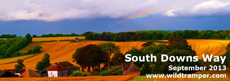
A delightful surprise as our rhythm took form during the first few days of walking the South Downs Way. It was as simple as using the local bus service to expand our radius. Short walking days allowed us to explore nearby communities at day's end, and these explorations were often the day's highlight. Along the way we visited Brighton for its pier and very good eats, to Lewes for Anne of Cleves House and Lewes Castle, to Arundale (on everything closed Monday) to view the exterior of lots of stuff, to Chichester for its upscaled avenues, to Worthing to view a poor man's Brighton, and we walked off track to Steyning for afternoon tea and views of fabulously old, timber constructed homes.
My journey with a friend was 13 days, walking 12 days and relaxing 1, plus a couple of days beforehand to explore Winchester and a few days afterwards to explore London. We walked an average of 8 miles a day with the shortest being 6 miles and the longest 12. We shortened two days by taking a bus in the morning to view nearby towns (such as Chichester) and then back to the track (but now shortened from the original 12 to 13 miles). We had one relaxation day in Amberley.

Winchester Cathredral |
This report describes our relaxing two week walk of the South Downs Way (SDW). The report also includes what to expect for weather, how best to navigate, what clothing & equipment to use, getting to/from the path, lodging & gear transfer, and a detailed itinerary & expense list with positive and a few negative comments.
Over the Stile |
Weather:
Having walked the Coast to Coast in 2010 I knew of England's fickled weather. Because September is touted as statistically drier I once again counted on my good luck for sunny skies. Undoubtedly, I was still in denial for what would come. Of the twelve day walk the first two days were hot and muggy, while the remaining days were cool, overcast, and sometimes wet. Only one day did the sky part with torrential rain, and thankfully our last walking day along the Seven Sisters Chalk Cliffs we were greeted with glorious sunshine.
But weather be damned, I found the adversity of walking in a sometimes foul climate a minor concern. Armed with good quality rain pants, Gortex rain shell, gators, and boots, I was prepared for what the elements could deliver. I always wore gators to keep the often wet track from soiling my feet, some of the time I wore rain pants, and when the weather turned foul I donned a Gortex rain shell.
Navigation:
WP |
Grid |
Elev |
Description |
Take-Along Waypoint Guide |
P001 |
SU4807 |
0 |
Old Vine Hotel, Winchester |
|
S001 |
SU4939 |
50 |
Head E on Five Fields Rd |
|
S002 |
SU4955 |
55 |
Over M3 bridge |
|
S003 |
SU4968 |
57 |
Zigzag L/R after bridge, then ESE |
|
S004 |
SU5014 |
67 |
Ahead, ESE |
|
S005 |
SU5062 |
65 |
Ahead, then bear R to S |
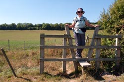
Although the SDW is well marked and is an easy track to follow, more likely than not you will go off path at some point. The important consideration is to learn of these errors and recover as soon as possible. In my opinion, there isn't any one navigation aid that will keep you on path, rather I recommend a minimum of two. These are a National Trail map of the South Downs Way and a handheld GPS. A GPS unit will tell you where you are, while the trail map will identify your location. A GPS unit can also guide you off track to at-the-moment side trips. Additionally, a guide book of the South Downs Way can be both useful and informative.
Happiness is a Bee in Thistle |
Before my walk I downloaded a map of Great Britain to my GPS, and I created a set of GPS waypoints for the path which identifies the main path from numerous alternate paths comprising about 250 waypoints. I also created a Take-Along Guide which identifies each waypoint, a milepost, OSGB coordinate, elevation, % grade, and a brief description. A snippet of this guide is illustrated here, while a comprehensive discussion of these waypoints and free downloads can be found elsewhere on my website at www.wildtramper.com.
When my companion and I were walking, we relied on my Garmin eTrex 30 GPS with downloaded waypoints and the "National Trail South Downs Way" map along with a South Downs Way guidebook for miscellaneous information. I copied (two-sided in color) sections of the unwieldy National Trail map and placed the now 8-1/2"x11" copies into a waterproof (Ortlieb brand) 9"x11" map carrier. I found using a map carrier both reliable and convenient, much more so than cumbersome sheet maps.
Navigation Issues:
Unlike other long tracks I have walked, I found the signing of the South Downs Way well marked. The only navigation issue is caution should be taken when crossing motorways.
Equipment:
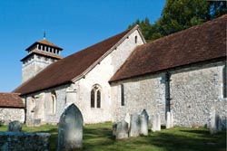
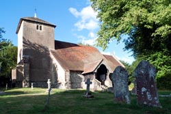
St Andrew's Church, Meonstoke |
Clothing:
While walking I always wore nylon pants, long sleeve light-weight wool shirt, sturdy waterproof boots, wool socks, gators, and a hat. When the temperature cooled down I added a nylon shirt and/or Gortex shell, and when the weather turned wet I also donned rain pants. While walking I almost never required any additional layers to stay warm, but my day pack always included a fleece shirt, wool cap, and light weight gloves that I sometimes used when taking a break. I recommend walking only with fast drying, wicking fabrics (e.g. nylon, fleece, and wool) and to stay away from cottons because as the adage says cotton kills.
I strongly recommend bringing a bomb-proof rain jacket. Bomb-proof means a rain jacket that is made of seam-sealed, three-layer-laminated, Gortex fabric, and a jacket with proper head protection, that is a hood which stays in place in heavy rain or wind, and a shell length sufficient to cover part of your lower body. I own both three-layer-laminated Gortex and lighter two-layer-lamented rain gear, and I have learned that the lighter weight materials do not stand up to prolonged foul weather. It pays to use what I call bomb-proof construction for best prolonged comfort in inclement weather as you will likely experience at some point along the path.
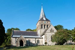
Parish Church of All Saints |
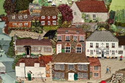
Tapestry |
Like rain jackets, I own various grades of rain pants. For the SDW I used a good quality, light weight, waterproof and breathable, nylon rain pant rather than bomb-proof Gortex. I wore my rain pants on two days, one of those through heavy rain. Whether sunny skies or not, I always wore gators to protect my legs from the wetness of the track and at other times from mud. I brought two hats, one to keep the sun off my thinning hair and the other with a large brim to shed rain from my face.
What I Carried:
I carried a small 25 liter day pack outfitted with a 2 liter Platypus through-the-straw drinking system. Among other things, the pack contained a personal first aid kit [dental floss, iodine, paper tape, nitrile gloves, second skin, protective mask for first aid/CPR, ibuprofen, acetaminophen, moleskin, various bandages, sew kit with various needles, scissors], LED headlamp, extra batteries, bandana, emergency TP, ditty bag [sunscreen, lip balm, deet (never used), hand sanitizer, eye drops], fleece shirt, wool cap, light-weight fleece gloves, and pack rain cover. Attached to the pack was a Garmin model eTrex 30 GPS with downloaded maps and waypoints. I carried a walking stick.
Other Logistics:
Reference Books and Maps:
• "The South Downs Way" by Kev Reynolds is a comprehensive book of the path. It includes numerous maps of the route and sites along the path. There are numerous other guide books available.
Wild Rose |
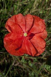
Red Poppy |
• Harvey's "National Trail South Downs Way" polyethylene maps are continuous strips to 1:40000 scale. This map identifies only the main route, while walking off track to nearby villages the map is often missing. Nonetheless, I found these maps useful to absorb a days journey. Before the walk I two-sided, color copied sections of the map to fit into a waterproof (Ortlieb brand) 9"x11" map carrier, the sections generally comprised one day's walk.
• My GPS was downloaded with Great Britian contour maps. Although these maps should be available through your GPS manufacturer, I chose to use free open source maps (from http://talkytoaster.info/ukmaps.htm) and I found these maps were both detailed and reliable.
• The National Trails South Downs Way website is at www.nationaltrail.co.uk/Southdowns. This excellent site lists numerous trail information including FAQs and lodging along the way.
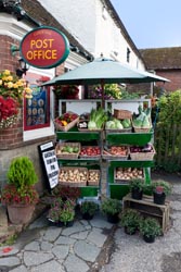
Convenience Store |
Gear Transfer & Lodging:
Unlike most people who walk the SDW, I booked my own lodging. I used Sherpa Van (www.sherpavan.com) for the day-to-day baggage transfer. Sherpa Van can also arrange accommodations. If you choose to book as I did, I recommend booking early. I booked nearly a year in advance and was able to pick almost any B&B or inn. I then selected Sherpa Van as my baggage transfer service. Now having used their service I would give them my highest recommendations. I used the National Trails South Downs Way website at www.nationaltrail.co.uk/Southdowns as an aid to find lodging.
Cell Phones:
Any unlocked, 4-band, GSM cell phone should work fine in England, the trick is to purchase the correct service provider. On this walk I purchased a SIM containing a few minutes with service by Orange and was very satisfied. Previously, when I walked the Coast to Coast in 2010, I mistakenly purchased a SIM from T-Mobile and then learned it had little to no service along that path. At that time one of the locals recommended Orange as a service provider. My actual purchase of the SIM was at the generic "Phones For U" store in Winchester at a bargain price of £10 for SIM and minutes.
Cocking 11th Century Church |
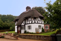
Thatched Roof Cottage |
Getting To/From the Track:
From Heathrow airport we took the National Express Coach (located between terminals 1 and 3) to Winchester. The cost was £19 per person and had a travel time of 1-1/2 hours. On return from Eastbourne we traveled by rail at a cost of about £15 to London Victoria Station.
Distance / Elevation:
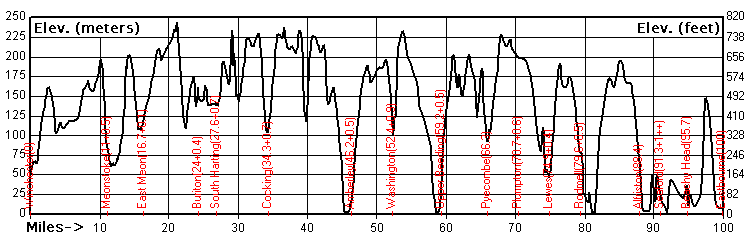
The above distance/elevation graph shows distance in miles and elevation in both meters and feet. From left to right the path travels from Winchester to Eastbourne. In between (identified in red) are towns, often off-track, with notations for milepost plus one-way off-track walking distance. The table below lists the distance from the start of track in Winchester to various towns, while the off-track distances is measured as the shortest walking distance to available lodging. Near Lewes the closest lodging to the track is the New Market Inn, a generic chain located on the A27 motorway, which is outside Lewes by about 2 miles. Likewise, the lodging in Seaford can be found at about 1 mile from the track but the sea is still another mile away.
|
Place |
Milepost |
Off-Track |
|
Place |
Milepost |
Off-Track |
|
Winchester |
0 |
|
|
Pyecombe |
66.3 |
0 |
|
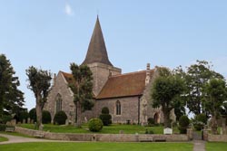
Meonstoke |
11.7 |
0.5 |
|
Plumpton |
70.7 |
0.6 |
|
East Meon |
16.7 |
1.0 |
|
Lewes - to Newmarket Inn |
64.9 |
0.4 |
|
Buriton |
24.0 |
0.4 |
|
|||
|
South Harting |
27.5 |
0.7 |
|
Rodmell |
79.6 |
0.5 |
|
Cocking |
34.3 |
0.7 |
|
Alfriston |
88.4 |
0 |
|
Amberley |
46.2 |
0.5 |
|
Seaford |
91.3 |
1 - 2 |
|
Washington |
52.4 |
0.9 |
|
Beachy Head |
95.7 |
0 |
|
Upper Beeding |
59.2 |
0.5 |
|
Eastbourne |
100 |
|
Chichester Cathedal |
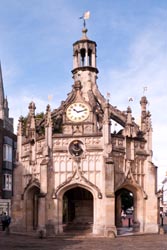
Chichester Clock Tower |
The Walk:
Thankfully getting to the start of the track from Heathrow to Winchester was a non event unlike the transit strike I endured during my previous visit to England in 2010. Leaving from the bus depot near terminals 1 and 3 at Heathrow Airport we arrived on a National Express Bus in Winchester, it was simple and relaxing. We checked into the wonderful Old Vine Hotel for two nights. My friend and I shared a spacious room with two queen beds, a large sitting area, and a fine bath. Certainly a grand start to our walking holiday.
That first afternoon we briefly explored Winchester. The first order of business was to start converting plastic into British Pounds as Winchester would likely be our only opportunity before reaching Eastbourne. That evening we had a light dinner at the nearby Slug 'n' Lettuce. It was a day that we endured the haze of jet lag.
A second day in Winchester was of simple business and exploring. The business was converting more plastic into British Pounds to cover anticipated expenses along the walk, and of purchasing a SIM for my cell phone. Nearby was a Phones For U store where I purchased a SIM with service by Orange for a bargain price of £10. This provided us with sufficient calling capability to confirm lodging as we walked the path, and best of all cell service had "many bars" along the track (unlike the T-Mobile service I chose when I walked the Coast to Coast in 2010).
Otherwise, we played tourist visiting Winchester Cathedral and the like. Although I'm not a shopper, I found the main avenue in Winchester quite pleasant. Along the avenues are many fine restaurants and that evening we dined at Loch Fyne Restaurant for a fine seafood dinner.
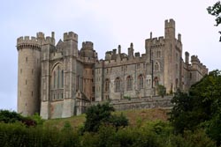
Arundale Castle |
Creekside in Arundale |
On the first day for our SDW walk we contemplated a bit before striking out: "Why kill yourself on the first day" my friend and I said to each other. So we had a slow start with a fine breakfast at the Old Vine, meandered around wonderful Winchester a bit, and then took a taxi to shorten our start from 12 miles to 6. We were dropped off along the A272 nearby Holden Farm. From there we walked in hot, muggy weather. As it turned out England had a record long hot summer, but that streak would last but one day more.
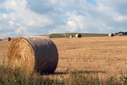
We found the track well marked and easy to follow. As we would learn, most of the SDW is located atop rambling hills with views of on ether side of the path of farm and pasture land. I observed that the fields along the western SDW were more browned out while those more easterly were more green. That first day ended in Meonstoke at the Bucks Head Inn. There we ate at the pub enjoying a fine beer and a good pub meal.
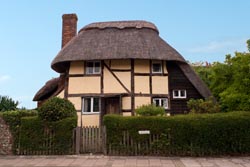
Thatched Roof Cottage, Steyning |
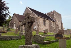
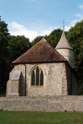
Our second day was another short walk, this time 6-1/2 miles to East Meon. More rambling hills and views of farms and pasture land, and as it turned out the last day of hot, muggy weather. We were leaning that what the track lacked in diversity the towns along the way added in charm. In East Meon we viewed the Parish of All Saints. Inside the parish hangs a beautiful tapestry depicting village life. That night we stayed at Ye Olde George Inn and had a fine meal. I particularly enjoyed their Fish Pie (with smoked haddock, salmon and king prawn topped with a chive and parmesan mash), yummy yummy.
On our third day we walked 9 miles to Buriton. The weather had taken a dramatic change to cool and overcast with threatening skies, but this was a welcome change from hot and muggy. As it turned out most of our remaining days brought threats of rain, but other than one period of hard rain we endured only sprinkles now and then. That night we stayed at the Maple Inn (formally called the Master Roberts Inn) but dined at the nearby Five Bells Pub. I enjoyed a most excellent Beer Battered Cod served with chips and peas. The cod was a huge fillet, nicely battered and quite tasty. Both my friend and I had fish and chips later along the walk, but none matched that from the Five Bells Pub.
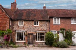
Old Steyning along Chruch Street |
On our forth day we walked 11-1/2 miles to Cocking. On this day we were mostly ahead or to the north or south of the impending weather. For the most part we stayed dry, only a few sprinkles befell us. At midday when the gloom was showering in the distance, I caught a rainbowed sky above the fruited landscape, my favorite photograph of the walk (see title photo). That evening we stayed and dined at the Bluebell Inn. Our dinner was wonderful, and although my main was grand what I will remember is the best desert I had along the track, a Hot Orange Curd and Marmalade Soufflé with Cointreau Ice Cream - absolutely decadent.
Church of St Nicholas in Bramber |
With a longer scheduled walk for the fifth day we discovered that by using the bus and rail system we could have the best of two worlds. Rather than walking 13 miles to Amberley we chose to play tourist in the morning in nearby Chichester. It was simple, we hopped a bus south along the A286. It was a fine diversion from the monotony of the downs. Chichester, like Winchester, has a fine shopping area and a wonderful Cathedral along with a delightful clock tower. Later that morning we hopped another bus to take us back to the track, but now to the SDW track intersection at the A285 motorway. We then walked about 7 miles to Amberley. Along the way the skies closed in so we donned our rain gear. Then it was a heavy rain, unrelenting for more than an hour, but we plodded on. As we approached Amberley the skies let up, but by now we were soaked on the outside, mostly dry on the inside with the exception of some soggy boots. We reached The Old Bakery, a homestay with a stupendous host. She welcomed us in, took care of our wet gear, and offered us tea and cakes. That evening, under clear skies, we dined at the Sportsman where both my friend and I agree we had our best main on the path. It was a meal of prime rib with Yorkshire pudding and a melody of roasted vegetables, and what we both liked most of the meal was the plethora of delectable sides balanced with a smaller portion of meat.
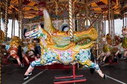
Brighton Pier Carousel |
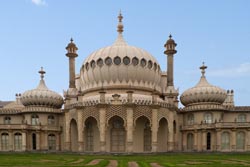
Brighton Royal Pavilion |
Monday was our sixth day. It was a day to kick back and relax, but as it turned out it was a day of trifling complexities. Our plan was to play tourist in nearby Arundel traveling to/from by rail. So we walked to the train station in Amberley and purchased round trip tickets. The next train was scheduled to arrive in a few minutes, but we soon learned there was an incident on the tracks and thus the train would be delayed. Rather than wait we chose to travel by taxi, but first we needed a phone number for taxi service. We called our host at The Old Bakery to get that phone number, and that very charming lady said she would pick us up and drive us to Arundale. Shortly thereafter we were in Arundel, a town with a lot of charm. Our hopes to tour the Arundel Castle were dashed as it was closed on Mondays beginning in September as were similar venues. Rather we walked around viewing sights from afar. For lunch we spied a tea room called Belinda's 16th Century Restaurant for a relaxing break and excellent scone. Later in the afternoon we arrived at the train station to find that the earlier incident of the day was still causing delays, so we chose to return by taxi. Anyone in need of two unused, expired, round-trip rail tickets? That evening we dined near Amberley at the Bridge Inn for a traditional pub meal.
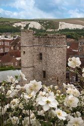
Lewes Castle |
The morning of our seventh day our host at the Old Bakery had presented us with now dried and cleaned clothes previously weather beaten from the rain two day's earlier, and nearly dry boots. My breakfast on that morning was new to me, a dish called Bubble 'n' Squeak. The version prepared consisted of smoked haddock, a poached egg, and sautéed potatoes, and it was quite good. After breakfast we walked 7 miles to Washington to arrive in early afternoon. We then chose to take the bus on the A24 motorway to Worthing, a place that is a poor man's sea resort. It has all the stuff you'd expect from a seaside town such as pier and hotels and restaurants and ice cream vendors, but most of it was in disarray. In late afternoon we returned by bus to Washington to relax at the Holt House, but our host was nowhere to be found. Rather, we waited in the Franklin Arms Pub, and as time passed we ordered dinner and began to worry that we would have to fend for other lodging. Thankfully a bit after 6:00 PM the note we left at the Holt House brought its proprietor to the pub and all was well. Certainly not a place I would recommend.
Southease Village |
On our eight day the plan was to walk the track to Upper Beeding. But along the way we chatted with a few locals who suggested a side trip to Steyning, and that we did. It made for a thoroughly enjoyable day. Steyning is a wonderful upscaled town. Upon arrival we found at the main cross roads (High and Church Streets) a delightful place called The Steyning Tea Rooms. That sunny afternoon meant enjoying lunch street side. I choose a Salad Nicoise and it was most excellent. After lunch we spied the old St Andrew's Church and the nearby museum. Along Church Street we walked past beautifully preserved old timber and thatched roof homes. Afterwards we walked to Bramber and then to our lodging called The Rising Sun in Upper Beeding. At the inn we learned that we missed the historic church and castle in Bramber so we strolled back for peek. At the top of a hill were remnants of a castle overlooking the country side, but other than one surviving castle wall the park was mostly a set of signs commemorating its history. That evening we dined at the Rising Sun having good pub food.
St Andrew's Church of Alfriston |
On our ninth day we walked to Pyecombe. Again the track provided views of farm and pasture land, but now we also had a view of the sea. With an easy walking day of 7 miles over rolling hills we arrived at Hobbs Cottage, a pleasant homestay, and then struck out for an afternoon of exploration. We found a nearby bus stop and traveled along the A23 motorway to Brighton. What a difference a few miles make. Unlike its poorer cousin of Worthing, Brighton is an upscale place with a brilliant beach, a grand pier, home to the Royal Pavilion, and numerous fashionable shops and restaurants. The Brighton Royal Pavilion, built in the Indo-Saracenic style over many years during the 19th century, was a retreat for King George IV ~ evidently he took after his ancestor King George III whose lavish spending was then paid for by taxing the new colonies of America into rebellion! That evening we enjoyed an outstanding seafood meal at Fishy Fishy on East Street where we both devoured scrumptiously prepared whole sole.
Harvest |
Very Berry |
By our tenth day of walking we had established a fine rhythm: Walk the rolling hills in the morning and then explore the nearby towns in the afternoon. The walk to Lewes was again to the same (and now monotonous) views of farm and pasture land. That afternoon we stopped at The Newmarket Inn located on the A27 motorway, a place chosen for it nearness to the track. At 1/4 mile off track, its mundane amenities were fine as the alternative was to walk 2-3 miles more into Lewes, a distance we left to alternate transportation. With a waning afternoon we chose to taxi into town so as to beat various 5 PM closing times of historic buildings. We viewed the Anne of Cleves House and then walked to view the Lewes Castle. Afterwards we asked a local for a good pub and ultimately hit the jackpot. That Friday night The Lewes Arms Pub was jumping and a place to be, a real village pub with great pub food and an exciting atmosphere. We were lucky to find a table, and chatting with the locals was our reward. Of course I devoured a banger on a roll with chips and a pint. Afterwards, again through the recommendation of a local, we meandered to the Snowdrop Inn for desert. Sitting outside on their patio we both enjoyed the very best sticky toffee pudding.
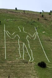
Long Man of Wilmington |
We had a short walk on our eleventh day. Just 6 miles to Rodmell, a place where I wanted to explore the history of Virginia Wolfe's retreat called Monk's House. Now a National Historic Monument, the house and its grounds were expansive. Having read most of her works, I could feel the tingles of her literary genius while exploring the grounds. Afterwards we arrived at The Rodmell House homestay with its delightful host, and I was lucky enough to get the room with the relaxing chair and the wood burning stove. I sat in that chair reading a book and I imagined a cold winter day in front of a warm fire. That Saturday evening we walked across the street to the Abergavenny Arms for a fine dinner at the pub and later that evening we enjoyed their live jazz music.
As the twelfth day approached the weather was flirting with us. To date we endured one afternoon of hard rain and at a few other times the skies spit at us. The weather report now looked more ominous, especially as the day progressed. With that forecast we got an early start for the 9 mile walk to Alfriston. Thankfully the skies cooperated and we reached Dean's Place dry by early afternoon. After checking in we roamed this delightful resort town. We then hired a taxi to take us for a viewing of the Long Man of Wilmington. As evening approached our original thought was to have a celebration dinner at this upscaled hotel, but when we took a gander at the menu we felt their choices limiting and prices stratospheric. Rather, we had a fine dinner at the non pretentious George Inn. Our return to Dean's Place after dinner was through umbrella testing, driving rain, and it seemed that a brilliant finale to the walk would be dashed.
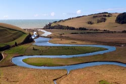
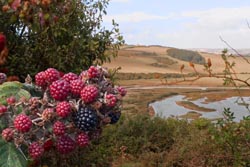
River Cuckmere to the Sea |
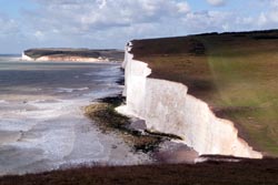
Seven Sisters Country Park |
We awoke on the thirteenth day to brilliant skies, the storm graced us by moving to the north. We fueled up early at Dean's Place to a disappointing institutional buffet breakfast, certainly not what I expected. Soon, we were ready to tackle our longest day of about 12 miles starting at the hour of slightly before 9 AM. The day was spectacular. Ahead of us we had brilliant weather, the meandering River Cuckmere, varied terrain, the ocean, and the Seven Sisters Country Park with its chalk cliffs. Rather than retracing our steps into the center of town, we headed south from Dean's Place following the River Cuckmere over a path that was a bit muddy from the previous night's rain. The river and its meadows were a delight. Soon we crossed a bridge to rejoin the formal SDW path. It was then climb, climb, climb over a forested ridge to West Dean and then down to the west end of the Seven Sisters Country Park. Here the River Cuckmere meanders in wide elegant sweeps cutting a path in lush green pasture and finally ending by flowing into the sea. No doubt my hopes for a dramatic ending was in the works. Although given the name "Seven," there are more than seven ups and downs along the chalk cliffs, and depending on how you count that number may be as high as 13. However many doesn't matter, the chalk cliffs were spectacular in splendor, grassy green on top and chalky white along the cliff edges. The pounding surf below and hazel blue skies above added to the magic. About half way across the cliffs was Birling Gap, a place where we stopped for an afternoon snack and a well deserved ice cream. Shortly thereafter on the bluff we reached the Beachy Head Lighthouse and below at beach level was another lighthouse, one that is more viable to seafaring ships when fog shrouds the coast. Soon we were as far east as we could travel reaching Beachy Head and the highest elevation of the Seven Sisters, about 156 meters (510 feet). Here we turned north and it was then all down hill to Eastbourne. We reached the Morgan Hotel at about 2:30 PM. It was a wonderful day with stupendous weather, grand views, diverse scenery, and an achievement completed.
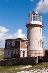
Belle Tout Lighthouse |
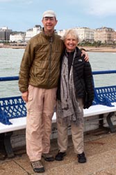
Eastbourne Pier Finale |
The next morning, our fourteenth day, after a fine dinner the night before at La Locanda Del Duca we strolled to the pier and asked a patron to take our picture for a remembrance of the walk. Late morning we boarded a train for London where we would play tourist to visit museums and enjoy theater. Three days later I boarded a plane for home.
Detailed Itinerary & Expenses:
The table below lists the places I stayed, various places I ate, and expenses I incurred along the South Downs Way but not including either my air travel or my post holiday in London. The expense column is listed in British Pounds while the totals are in both British Pounds and US Dollars. Unless otherwise stated all lodging is for single, ensuite rooms with bed and breakfast, while an "ea" suffix in the cost column indicates a shared room each cost. The comment column generally denotes favorable impressions, but there are exceptions.
|
Date |
£1,464 |
Description |
Comments |
|
|
£30 |
• Guide book: (Cicerone) The South Downs Way guidebook
|
|
|
9/2 |
£19 |
• Arrive Heathrow, National Express Bus to Winchester
|
|
|
9/3 |
£70 ea |
• Layover, stay Old Vine |
• Excellent seafood dinner at Loch Fyne |
|
9/4 |
£55 |
• Meonstoke, stay Bucks Head (01489-877-313) |
• Nothing fancy, quite satisfactory |
|
9/5 |
£60 |
• East Moen, stay Ye Olde George Inn (01730-823-481) |
• Nice rooms and great dinner |
|
9/6 |
£68 |
• Buriton, stay The Maple Inn (01730-267-275) |
• Dinner at Five Bells |
|
9/7 |
£70 |
• Cocking, stay The Bluebell (01730-810-200) |
• Great meal, BEST desert of Orange Soufflé |
|
9/8 |
£45 |
• Amberley, stay Old Bakery
(01273-252-272) |
• Very gracious host, highly recommended
|
|
9/9 |
|
• Train side-trip to Arundale
|
• Oops, September Mondays all closed
|
|
9/10 |
£35 |
• Washington, stay Holt House |
• nix, nix, nix, very disappointing |
|
9/11 |
|
|
• Relaxing lunch at The Steyning Tea Rooms
|
|
9/12 |
£40 |
• Pyecombe, stay Hobbs Cottage
(01273-846-150)
|
• Very nice host
|
|
9/13 |
£35 ea |
• Lewes, stay Newmarket Inn
(08458-053-478)
|
• Near track, saves 2 miles off-track walk
|
|
9/14 |
£45 ea |
• Rodmell, stay Rodmell House
(01273-479-620)
|
• Very nice host
|
|
9/15 |
£55 ea |
• Alfriston, stay Deans Place
(01323-870-248)
|
• Overrated, dreary buffet breakfast
|
|
9/16 |
£40 ea |
• Eastbourne, stay Brayscroft Hotel
(01323-647-005)
|
• Fine hotel
|