
Click SaddlebagReport.pdf for a copy of this report and large map, OR click to view the photo gallery.
Saddlebag Lake &
20 Lakes Basin Loop Walk
Click for PDF of Large Map & Report |
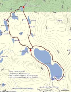
An always favorite walk when I'm on the eastern edge of Yosemite is the 8 mile stroll, about 250 feet gain/loss, from Saddlebag Lake into 20 Lakes Basin. It's an easy loop walk which skirts eight of the twenty lakes, and along the way the path passes imposing granite features, wildflowers, many lakes, and if you're lucky numerous birds. The trailhead at GPS(37.964818, -119.272074), 10,100 feet, is located at the end of the 2-1/2 mile Saddlebag Lake Road (mixed dirt and asphalt) which junctions with Tioga Road, Highway 120, at GPS(37.938275, -119.248611). That junction is 2.3 miles northeast of Yosemite's eastern park entrance or 10 miles west along 120 from Lee Vining.
At the lake is the Saddlebag Lake Resort. In addition to the Cafe and General Store, the resort provides, among other things, water taxi service for transport across Saddlebag Lake.
Over the years I have enjoyed this walk after both wet and dry winters. This report was written after my walk in July of 2012 which followed a dry winter. The lake levels were then noticeably low and the surrounding peaks were mostly barren of snow. Two years earlier in August of 2010, after a wet winter, the peaks were alive in bountiful snow while some of the walking paths were still laden in white. That was a fun year, where at one point I had to shimmy up a narrow slot of cascading water to avoid the snow to rise above Lake Helen on its western side to reach Shamrock Lake on my return.
The path around the lakes is easy to follow, but a bit of simple off-trail scrambling is necessary between Lake Helen and Shamrock Lake. In this area the trail is marked with cairns [normally 3 or more rocks stacked to identify the path], so as you reach one cairn eye the horizon for the next.
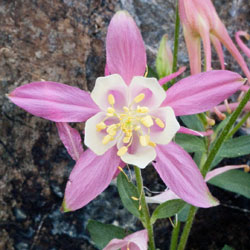
Sierra Columbine |
If you plan to walk the 8 mile loop, I recommend a counter-clockwise direction. Start by walking the east side of Saddlebag Lake, then continue to Hummingbird Lake, to Odell Lake, and to Lake Helen. At the creek outlet at the northeast corner of Lake Helen, GPS(37.98115, -119.28655), cross the two-log bridge over the creek and then follow the trail around the lake. About halfway around the west side of the lake the trail turns west and starts to gain elevation. Soon the uphill footpath changes to off-trail, granite scrambling, marked by cairns. Shortly you'll reach the top to intersect the easily identified footpath again. From here follow the trail to Steelhead Lake, to Wasco Lake, past Greenstone Lake towards Saddlebag Lake. I normally return on the west side of Saddlebag Lake, but to get there you must cross the rushing outflow from Greenstone Lake. Follow the trail west as you approach Saddlebag Lake (among the plethora of use trails) to another two-log bridge, GPS(27.98026, -119.28714) to cross the creek. If you are unable to find this mostly hidden two-log bridge, parallel the rushing creek between Greenstone Lake and Saddlebag Lake, and miraculously the bridge will appear from within the brush.
Although the walk can be done in either clock or counter-clockwise directions, I prefer the latter because the modest technical section between Lake Helen and Shamrock Lake is uphill rather than downhill. If you like to photograph flowers or just enjoy viewing something special, the spectacular Sierra Columbine blooms, generally late July and August after the snow recedes, along the east shore of Helen Lake.