
This report is divided into creative writing and creative (maybe mundane) information at the end for those interested in directions with GPS coordinates and review of new equipment. Click on MarblesReport2009.pdf for a PDF copy of this report. You may also be interested in my 2002 adventure to the Marbles, a trip that I think was much more interesting. And if you want to view larger versions of the pictures, look at the slide show.
Marble Mountain Wilderness ~ 7 - 9 July 2009
Marble Mountain |
A Bit Of History
The Marble Mountain Wilderness is one of my favorite destinations, I have now tramped there four times.
• My first visit was a week long tramp in the southern area, traversing a loop starting along the Garden Gulch Trail with visits to Pine Lake, Hancock Lake, English Lake, Abbot Lake, Lake Ethel, and Lake Katherine, and competing the loop along the North Fork of the Salmon River.
• My second visit was four days in the north western area, completing a loop starting at Sulphur Springs campground traveling along Granite Creek to Burney Lake, Spirit Lake, Rainy Lake, and Paradise Lake, and completing the loop via Bear Creek.
• My third visit also started at Sulphur Springs campground with visits to Blue Granite Lake, Cuddihy Lakes, Onemile Lake, and Ukonom Lake, returning to complete a near loop via the Tickner Trail. Visit my website for the 2002 narrative of this great five day outing.
• This visit was my forth, a trip to the north-east corner designed to be laid-back with a short five mile tramp into Little Elk Lake for a base camp, two layover days to explore, and a tramp out - or so it was planned!
In retrospect, my favorite Marble Mountain area is that accessible from Sulphur Springs, followed by the route I took on my first venture here. Although my side trip to Deep Lake was quite enjoyable, Little Elk Lake was at best disappointing.
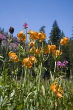
Tiger Lilies |
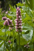
Horse-Mint |
More Marble Mountain history can be taken in at the museum in Happy Camp. There you can purchase a wonderful book entitled "In the Land of the Grasshopper Song" which is the 1908-09 adventure log of two young women, Mary Ellicott Arnold & Mabel Reed, in their Indian Service appointments as field matrons for the Karok Indians in the Klamath and Salmon River area. Besides the narrative, the old time pictures are amazing. A must read.
The Drive Up, Monday, July 6
From my home in the Sunnyvale in the San Francisco Bay area, I drove 7 hours north to almost the California/Oregon border where the Marble Mountain Wilderness resides to the west of I-5. Along the way I stopped in Williams at Granzella's, a favorite roadside haunt, for a grand chili-burger lunch. The day's drive ended in Yreka at the Motel 6 - I guess I'm getting lazy because I didn't want to set up and then break down camp near the trailhead. Had I chosen to camp rather than motel, the Forest Service has two very excellent choices near the trailhead. One is Indian Scotty campground along the Scott River which is 7 miles from (and 1600 feet below) the trailhead, and the other is Lovers Camp which is at the trailhead. Both are quite nice and both seemed to be sparsely used.
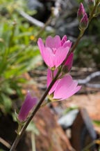
Bluff Mallow |
Tuesday, July 7
Getting an early start, I drove the final 38 miles from Yreka to the trailhead (in about 1 hour), first traveling 15 miles on CA-3 to Fort Jones, then turning right onto Scott River Road traveling 14 miles to Indian Scotty Campground, thereby crossing the creek onto 44N35 traveling 5.3 miles up the excellent (but sometimes narrow) paved road making a sharp left on 43N35 (also paved) and traveling the final 1.7 miles to Lovers Camp and the trailhead. I was surprised and pleased that the Forest Service roads to the trailhead were paved. However, if your destination is Paradise Lake (a great place), 44N35 past the 5.3 mile point turns to dirt. The side road 44N53 to access Upper & Lower Wright Lakes is also dirt.
At the well used trailhead (by the quantity of cars there) I met a couple and their Doberman who spent the night at Lovers Camp. They too were heading to Little Elk Lake, they planned to visit Deep Lake on Wednesday, and return on Thursday. But they were in the relaxed, go slow mode. I on the other hand was ready to get on the trail to enjoy Mother Nature's best. At 9:15 I was on my way, walking southwest and paralleling Canyon Creek (to the south). 30 minutes later I reached the first trail junction, taking the south fork towards Red Rock Valley. A few steps later was my first of three creek crossings, this one didn't have great rocks to cross on. Rather, I choose to play it safe and just sloshed through the 6 inch deep water, shallow enough to keep my socks dry.
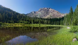
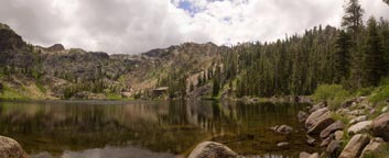
Little Elk Lake |
Wild Hollyhock |
The trail continued upward with various meadows along the way full of wonderful wildflowers - thus it was photo-op time. Just after one of these meadows at 11:05 was a side-creek crossing and then immediately after the crossing on the left was an established campsite (GPS identified between Jct 1 & Jct 2 below). I continued paralleling Red Rock Creek until 11:25 when I crossed the creek and then immediately reached the trail junction (Jct 2) to Little Elk Lake, taking the east fork. From here the trail slogged upward with numerous switchbacks. At 12:30 I reached the high point (6010 feet) and then meandered (600 feet) downhill to Little Elk Lake.
Although I reached the lake at 1:00, it took me awhile to find a campsite. I had hoped to make home near the northeast corner of the lake where I might get afternoon sun. I crossed the creek at the lake outlet only to find there were absolutely no viable sites on that side of the lake, and that was the good news. The bad news was the trail which I assumed went to Summit Lake was grossly overgrown and nearly impassible. I returned to the west side of the lake and ultimately found an established campsite which I used to make home.
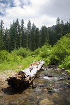
Creek Crossing |
After setting up camp, the darkening skies broke loose with maybe 50 rain drops. The entire day was cool, great hiking weather, but it was now time for sunshine. As I learned, the daily weather pattern was cold at night (in the high 30s), clear in the AM, clouding up in the PM with threats of sprinkles, and daytime highs maybe reaching 70.
The remainder of the day I relaxed by the lake, mostly reading a book. My neighbors who I met at the trailhead had arrived, and I gave them the rundown of what I learned about the lake and told them about the other camp site just to the north of mine. They dropped their packs at their new home and then explored while their Doberman played fetch-the-stick in the lake.
No doubt I was disappointed with Little Elk Lake. Besides less than optimum campsites, the lake perimeter is bog and marsh with literally no easy access to the water. And with bogs come bugs, the mosquitoes were definitely a nuisance. But Wednesday would be a relaxing trip to Deep Lake.
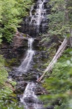
Waterfall |
Wednesday, July 8
It was going to be a lazy day, get up late, meander the 3-1/4 miles and about 1000 feet elevation gain to Deep Lake, take lots of photos. As mentioned, weather started bright and sunny and then progressed to overcast. There were plenty of opportunities to enjoy and photograph wildflowers. The best areas were near the two lakes. First the area near the outlet of Little Elk Lake was abundant with flowers and then once I approached Deep Lake, where there are numerous springs, Mother Nature's growth of beautiful color flourished.
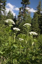
Cow Parsnip |
Shortly after crossing the outlet to Little Elk Lake is a side creek with a magnificent cascading waterfall. Beautiful to view, but being predominately north facing it had problematic photo presence. But the photographic problems of the waterfall were made up because the abundant water generated exuberant foliage, something in mid July means wildflower blooms.
Once past the waterfall, the trail pleasantly climbs through forested areas until you get to within 1/4 mile of Deep Lake. Here, there are numerous springs along with lush meadows and abundant wildflowers. At about this point is a nearly worn out trail junction marker identifying the path to Deep Lake to the south and Wright Lakes to the northeast. Unless the marker is replaced soon, I would not be surprised if it totally disappeared in a year or two, so if you have a GPS it might be advisable to set a way-point at what I call Jct 3 in the table below.
Deep Lake |
From the junction the trail gained a bit more elevation while it passed through an area of several springs. Here the trail was often wet and muddy, but was otherwise easy to follow. A short distance later was a view of the lake. I chose to head to the shoreline just to the east of the north side creek outlet. There are several very nice campsites in this area, and there may be others further along the northwest shoreline.
After a pleasant lunch at lakeside, I retraced my path back to Little Elk Lake. Along the way I was treated with a wonderful exposé of a Washington Lily, a new sighting for me.
When I reached Little Elk Lake I took a short side trip to Burton Cabin. It is located 10 minutes north of the lake on the west side of the creek. The cabin was in well aged condition. At the cabin were a pair of guys who looked like they were having a long term stay. They brought in lounge chairs, fishing gear, a pellet rifle, lots of food, and even a mask & snorkel. What a way to squat!
Even though I had planned to have two layover days at Little Elk Lake, I decided to cut it short mostly because the lake was a big disappointment. Little Elk Lake was too much like a marsh to lounge around, and a side trip the next day of hacking my way along the overgrown path to Summit Lake was more than I was interested in.
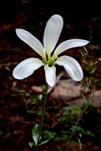
Washington Lily |
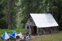
Squatting Burton Cabin |
Thursday, July 9
I got a moderately early start, eating breakfast and breaking camp. I was ready to go at 9:15. Except for an initial climb of 600 feet, the journey out was basically downhill. Along the way I stopped several times to play photographer at various meadows with wildflower blooms. I reached the trailhead at about 1:00.
After cleaning up, I started the arduous drive home. Of course I stopped for dinner at Granzella's in Williams. Back on the road, the traffic was light until I hit night time highway construction near Fairfield on I-80. At 10:00 I arrived home, a much too long a day - but an otherwise enjoyable adventure.
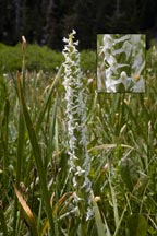
Bog Rein Orchid |
New Equipment Review
Thermorest NeoAir Mattress: I must have at least six air mattresses, so why buy another. Well, I thought I'd try the full length NeoAir to replace a 3/4 length Prolite-4. The long NeoAir weights15 ounces, the same as my 3/4 length Prolite-4. Of course it's not as comfortable as a full length Camprest, but the extra length and 2-1/2 inch loft is an improvement. On the downside, it doesn't work nearly as well with the Thermorest camp chair because of its 2-1/2 inch loft - I found that I had to significantly under inflate the NeoAir when used with the chair which makes the bottom cushion too soft, but fortunately my standard equipment includes a sit pad which I use to solve the bottom cushion problem. The other shortcoming with the NeoAir is it doesn't seem to insulate as well as a Prolite-4. Not nearly perfect, but ok.
Eureka Spitfire 1-Man Tent: This tent replaces a similar 1-man tent from Sierra Designs called their Light Year 1. Although the Spitfire weights a tiny bit more (56 versus 53 ounce for my packed weight with ground cloth), it has much more head room, enough to sit up while in a Thermorest camp chair. Definitely a big improvement. The downside (which is the same for the Light Year 1) is I tend to limit out in length because of my 6' 2" frame.
Directions & GPS Locations
|
Category |
GPS |
Alt |
Place |
Description |
Real Meals |
|
|
Williams |
Granzella's is a great place to eat - any time. |
To/From Trailhead |
|
|
|
To reach the trailhead from Yreka: (a) Travel 15 miles on CA-3 to Fort Jones, (b) turn right onto Scott River Road and travel 14 miles to Indian Scotty Campground, (c) Cross the bridge onto 44N35 and travel 5.3 miles up the excellent (but sometimes narrow) paved road, (d) Make a sharp left on 43N35 (also paved, but further than this point 44N35 becomes dirt) and travel the final 1.7 miles to Lovers Camp and the trailhead. |
Main Trail: Lovers Camp to Little Elk Lake |
10T0488238 |
4075 |
Lovers Camp |
From the Lovers Camp trailhead, the trail parallels Canyon Creek where in less than a mile is a trail junction (Jct 1), take the south fork towards Red Rock Valley, the other path follows Canyon Creek into Marble Valley. Once on this path the trail crosses Canyon Creek and continues uphill where it ultimately parallels Red Rock Creek. Then the trail crosses the creek and you immediately reach the junction (Jct 2) to Little Elk Lake. Take the east fork uphill through numerous switchbacks. The high point demarks milepost 3.75, from there another 1 mile downhill to Little Elk Lake. There are two good campsites near the northwest corner of the lake, the one I used is marked with the GPS is the smaller of the two, and it is just south of the bigger/better campsite. |
10T0487503 |
4202 |
Jct 1 |
||
10T0487922 |
4981 |
A Campsite |
||
10T0487890 |
5180 |
Jct 2 |
||
10T0488440 |
6010 |
High Point |
||
10T0488982 |
5397 |
Little Elk Lake Camp |
||
North of other camp |
|
Better/Bigger Campsite |
||
Deep Lake |
10T0490660 |
6236 |
Jct 3 |
From the lake outlet follow the trail north and slightly east around the mountain in a counter-clockwise direction. Shortly after the lake outlet is a side creek crossing where a stunning cascading waterfall can be viewed. After about 2-3/4 miles you reach a decaying trail marker (Jct 3) demarking Deep Lake to the south and Wright Lakes to the north. Shortly thereafter on the way to Deep Lake are numerous springs where the trail becomes wet and muddy, then expansive meadows, and finally Deep Lake. Camp sites seem to be located along the northwest corner. |
10T0490647 |
6328 |
Lake Outlet |
||
Summit Lake |
|
|
|
Immediately from the east side outlet of Little Elk Lake is an overgrown trail which I assume leads to Summit Lake. I explored this trail to a minor degree using my GPS to verify the path I was following was likely correct. Besides the obvious overgrowth, there were also many downed trees. I proceeded about 1/4 way around Little Elk Lake before I lost interest. |