
This report is divided into creative writing and creative (maybe mundane) information at the end for those interested in directions and review of new equipment. The section on directions lists my favorite paths, favorite campsites, and GPS coordinates. The new equipment section may give you ideas. This report also fulfils requests from my fishy friends to enquire what the fishing conditions were, so if you're a fisherman, read on. Click on EmigrantReport2007.pdf for a PDF copy of this report.
Emigrant Wilderness ~ 6 - 10 August 2007
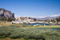
Emigrant Wilderness |
The Drive Up
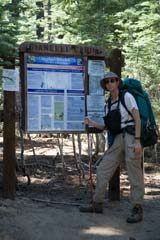
The best and maybe only part of the drive up that is worthwhile is getting fed before the outing. After reaching the Summit Ranger Station in Pinecrest and obtaining a wilderness permit, I drove 6/10 mile down the road to the Steam Donkey for a soon-to-be well deserved meal. Burger with a side of fruit, ice tea, and an outdoor table with a view of the Sierra forest. Certainly a pleasant beginning. After lunch, a short but time consuming 15 mile drive to the Gianelli trailhead to Emigrant Wilderness for the start of my outing.
Monday, August 6
After driving to the Gianelli trailhead, I tramped 2 miles to Powell Lake and set up home at my favorite campsite. Other than a group of a dozen naked ladies on the other side of the lake, I had it to myself - well maybe the ladies weren't naked, but they did cackle loudly. It was at this lake that I observed my one and only jumping fish, but more of this later. Because (and in part throughout the trip) of the breezy conditions, there were no bugs [great!] but at dusk there were also no bats [dang!].
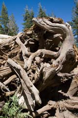
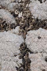
Downed Tree Root |
Tuesday, August 7
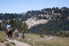
The next day I tramped 8 long miles to Wire Lake. On the way I encountered a very scary situation: The wild Sierra cows in Whiteside Meadows - I suspect the purveyor of these beasts has a grandfather clause to use the wilderness for summer grazing - but please, let's let grandfather rest in peace. I also passed (or should I say they passed me) a group of horseback riders. Lots of dust, but otherwise a great way to get outdoors.
Later, while taking a break in Salt Lick Meadow I viewed one of many hawks. This one was being hounded by a smaller bird, it was quite a show. Then at dusk while at Wire Lake relaxing on the beach, I was treated to wonderful shows of small birds. Many were hopping along the shoreline looking for an evening meal and some hopped as close as ten feet from my meditative position.
Alternate Locomotion |
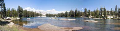
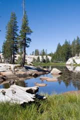
Yes, at Wire Lake I found a grand campsite - it was on the east side of the lake and got afternoon sun, it had a sandy beach (where I had all my meals), it had granite rocks to sit on, it was just wonderful. I believe this was the same site I was at in 2002. I spent two nights there and I would definitely consider it as a destination again. My first night I had the lake to myself, the second night there was a family group on the other side of the lake. Other than early mornings there was a constant breeze, and thus it was difficult to see any fish jumping in the choppy water. Later on I learned that a very good place to fish is the 3rd (of 3) and largest and lowest Wire lake - he said "it's the best camping and least used Wire Lake, and also has good fishing." I have been curious of the other two Wire Lakes, maybe next time I'll make it a destination.
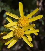
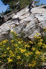
Threadleaf Groundsel |
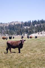
Wild Sierra Cows! |
Wednesday, August 8
On my layover day I did almost all I had intended to do which I had also intended to do two years earlier but then got pleasantly lost. My goal was to day tramp to Leighton Lake by way of Wood Lake and Karls Lake, but by the time I finished a late lunch at Karls Lake it was already 2 PM, so that was it. It was definitely a great day, I only got minimally lost. Karls Lake was certainly worth the effort, it would be a nice destination to get away from everyone. It is a medium-large, low depth lake pot marked with many small islands and has dozens of fingers. I suspect there would be little or no fish. To get to Karls Lake read the section on Directions. During the 8 hours of the day's tramping, I probably traveled 12-15 miles. My GPS came in very handy to find the hidden trailhead and to guide me out of Karls Lake.
Karls Lake |
Early on this layover day I met a bone fide fly fisherman, he wanted to fish the streams but was very concerned for the fish since the water levels were way down. Compared with 2005 (a very wet year), the meadows were quite dry and creek flow was low. I suspect further out near the Cherry Creek drainage it would have been better [I was in that area in 2002]. The fish he did catch & released were 10-12 inch in size. He seemed knowledgeable about the history of fish in Emigrant saying that they are all planted, some are rainbow and others are landlocked salmon - it must have been the salmon variety I saw in 2002 that was 20 inch or more. He was with a couple friends who had there food and some gear packed in, complete with float tubes. They were staying at Deer Lake and would pack everything out themselves. He commented at the many, many people in Emigrant, although I hadn't observed this where I camped, but I suspect Deer Lake is a primary destination as I know Wood Lake is. On my way out on Friday I observed his comment first hand when I saw hoards of both day trekkers and overnighters at all the lakes I passed.
Wire Lake Morning |
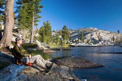
Wire Lake Beach at Sunset |
Still on my layover day, I passed a teenage boy and his grandfather camping near the dogleg neck of Wood Lake. They trekked in 12 miles the day before ~ ouch, that hurts! They were both fishing, more hackers like myself than fishing artist, and they said they were catching 10-12 inch trout in Wood Lake using spinning gear. I suspect Wood Lake and also Deer Lake are productive destinations for all including hackers.
2 km from my camp before returning on my layover day I conversed with a pair of gents completely outfitted in fly fishing gear. They were camped at nearby Long Lake which is about 1/2 km long (north/south). They both had very long fly rods and were wearing chest height waders. I knew from my last trip that Long Lake has access at both north and south ends, I learned from these gents that (I assume) with the aid of the waders you can travel (and fish) from north to south. It was at the south trail access I met them where they were hiking in their chest height waders to their north access campsite. I never asked how uncomfortable hiking was in that paraphernalia. They too commented at the difficult fishing this year.
High Relief Valley |
Thursday, August 9
Thursday I packed up and tramped to High Relief Valley, a place I wanted to view. It was a short hiking day, about 5 miles. I chose the locale in part because it is a reasonable distance (8 miles) from the trailhead for the next day's outing. When I reached the high meadow of the valley, I was treated to a carpet of blooming high mountain lupine and owls clover. Most everywhere else the wildflowers were past peak. Earlier in the season there must have been a beautiful carpet of large yellow flowers, but these had now all gone to seed. The lakes in High Relief Valley are not named, but I would call it High Relief Swamp or Bog.
Evangelical |
While at the lake of High Relief Valley, I realized that the abundant scat on the tops of granite boulders was caused by marmots. Some was perched on top of difficult to get to places. It must be a "king of the hill" marmot game, or maybe Ma Marmot says "don't do that in my living room, go outside!". There was so much scat in some places that you could use your imagination and make images out of the all that stuff. At one spot I saw what looked like a cross, it must have been the evangelical marmots. I was hoping to find the Virgin Mary in all that stuff, then I could have been famous like the guy who sold his grilled cheese version on eBay.
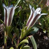
Alpine Gentian |
Friday, August 10
Friday morning I got up at 6:15 AM for an early start. The sun broke over the east ridge at 7 AM and by 8:15 AM I had breakfast and was packed and ready to go. Why does it always take so long to get ready? The early part of my tramp out was uneventful. By the time I reached the trail junction to Toejam Lake I started meeting the raft of people going this way or that, but at that point mostly going out to the trailhead. Having been starved for conversation from the previous few days, I must have spent an hour (on and off) chatting with other hikers. The most interesting was a father and son (about 14). They were out for 5 nights and covered an ambitious territory: Starting out the first night at Toejam Lake (8 mile); to Emigrant Lake (10 mile); to Emigrant Meadow Lake via Horse Meadow (7 mile); over Brown Bear Pass to Lower Relief Valley to High Relief Valley (10 miles); to Y Meadow Lake (4 mile); and out (6 mile). The son didn't say much, but when I commented about the climb from Lower Relief to High Relief Valleys, he grunted and said "yea!" The father also described some of his backcountry skiing, saying he enjoyed snow camping in the high country of Emigrant Wilderness and "it's nice making track in virgin snow." He said he was trying to get his son interested in backcountry skiing, but he seemed to prefer snowboarding. The father had not been to any of the Sierra Ski Huts, so I recommended the Bradley Hut. He did have the same complaint with Peter Grubb Hut as I, that is the bountiful amount of live bowling pins to hit in the tramped down, icy, downhill snow of that area.
Another Nice Mudhole |
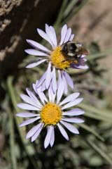
Alpine Daisy & Bee |
Another interesting person I met was wearing his volunteer Forest Service garb carrying a big shovel. I asked if backpack food really gave him that much trouble, and he said "not always, but it does come in handy." He was the one who recommended the 3rd Wire Lake. I enquired about not seeing signs of bear and he said they are skittish of people very much unlike the bears of Yosemite. He said there is essentially no bear problem in Emigrant, and even hanging food rather than using a bear canister works, although not recommended. I told him my story of the BIG teeth marks in my bear canister from my last trip to Yosemite, he was happy to learn that the Garcia brand bear canister he uses is the same one that I proved by experience.
Anyway, time was passing, so I reduced my chatter and headed out. Lots of people going in and out. I stopped for lunch at the crest with a grand view of Chewing Gum Lake and Lake Valley. Another 1-1/2 hours and I was at the trailhead, it was just after 2 PM.
During the trip, I stopped many times to take pictures with my big camera attached to my heavy and versatile tripod. Each time I took out the equipment, at least 20 minutes would pass, I guess this is as good a reason to go solo. Although my preferred subject is wildflowers, Emigrant was definitely past peak. No doubt the very low snow levels this past winter had taken its toll. I did take many pictures of landscapes such as the various lakes I visited.
After cleaning up, I stopped in Oakdale at Cocina Michoacana for a grand Mexican food dinner, yummy, yummy. Traffic going to the mountains on this Friday afternoon was its usual mess, fortunately I was traveling in the opposite direction.
Bouquet of DYCs |
New Equipment Review
Mont-Bell Thermawrap Jacket: I first saw this jacket while on a local outing, a friend was wearing one. At 9 ounces (for a large), it is warmer, more versatile, and lighter than your typical 100-weight fleece (12 ounces). It has hand pockets which the fleece does not, and it stuffs into a similar sized package. I bought it on the web for about $120. Definitely a 10 on the good gear scale.
Thermarest Sit Pad: While recently at REI, I made one of those instant purchases after seeing this thing. It's made of Therarest's Prolite 4 material into a sit pad, it weights 4-1/2 ounces, blows up with just one breath, and compacts to a very small package. My original idea was to use it as a supplement cushion for air travel, but I thought I'd try it in Emigrant. How do you spell comfort? It's orders of magnitude better than your typical foam pad. What's more, I used it as a foot-rest supplement to my short Prolite 4 sleeping pad, I got to inflate the sleeping pad to one level and the foot-rest to another. Very nice.